1930s Maps of North Hooper, Illinois
Explore 2 historic maps of North Hooper from the 1930s. These maps offer a rare glimpse into what life looked like during the 1930s — showing old roads, neighborhoods, homes, and landmarks that have changed or disappeared over time.
Whether you're researching your family's past, planning a metal detecting trip, or studying how North Hooper's landscape evolved across the 1930s, these high-resolution maps are a powerful tool for exploring the history of this region.
- Focus on a specific era: All maps on this page are from the 1930s, giving you a focused view of this time period.
- See what’s changed: Compare century-old streets, trails, and buildings to today's modern landscape using overlays and satellite layers.
- Research with precision: Use these maps for genealogy, historical research, land use analysis, or educational projects.
- View, download, or print: Maps are fully viewable online in high resolution, and can be downloaded or printed for your own records.
Start exploring North Hooper's history through authentic maps from the 1930s. This is your window into the past.
North Hooper, IL maps
(2)- 1935 Map of Watseka
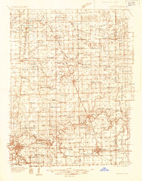 1935 Watseka1935 Print · USGSIroquois County in the mid-1930s is a landscape of thriving rail-side villages and rural school districts connected by a dense rail network. Researchers can trace family history through dozens of landmarks like Independence Sch, Mt Taber Ch, and St Joseph Cem.
 - 1939 Map of Watseka
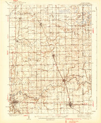 1939 Watseka1939 Print · USGSIroquois County and the Illinois-Indiana borderlands are captured here during the mid-1930s as a thriving rail and agricultural corridor. Researchers can trace dozens of country schools like Weygandt Sch, small communities like Beaverville, and the grounds of the County Farm.2 unique versions available
End of results
Showing maps 1-2 of 2
Top cities near North Hooper
- Kankakee historical maps
- Bradley historical maps
- Watseka historical maps
- Momence historical maps
- Kentland historical maps
- Sheldon historical maps
See more
Frequently asked questions
- What are the different types of historical maps available for North Hooper?
- What is the oldest map of North Hooper?
- Where can I purchase historical maps of North Hooper for my home or office?
- Where can I download high-res historical maps of North Hooper?
- Are there historical topographic maps available for North Hooper?
- Is there historical aerial imagery available for North Hooper?
- Where are historical maps of North Hooper sourced from?