1970s Maps of Fieldon, Illinois
Explore 1 historic maps of Fieldon from the 1970s. These maps offer a rare glimpse into what life looked like during the 1970s — showing old roads, neighborhoods, homes, and landmarks that have changed or disappeared over time.
Whether you're researching your family's past, planning a metal detecting trip, or studying how Fieldon's landscape evolved across the 1970s, these high-resolution maps are a powerful tool for exploring the history of this region.
- Focus on a specific era: All maps on this page are from the 1970s, giving you a focused view of this time period.
- See what’s changed: Compare century-old streets, trails, and buildings to today's modern landscape using overlays and satellite layers.
- Research with precision: Use these maps for genealogy, historical research, land use analysis, or educational projects.
- View, download, or print: Maps are fully viewable online in high resolution, and can be downloaded or printed for your own records.
Start exploring Fieldon's history through authentic maps from the 1970s. This is your window into the past.
Fieldon, IL maps
(1)- 1975 Map of Nutwood, 1978 Print
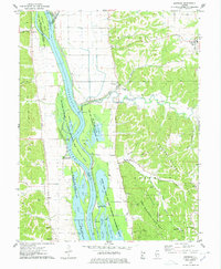 1975 Nutwood1978 Print · USGSAlong the Illinois River in the mid-seventies, this survey reveals the dense backwaters and bluff-side communities of Jersey and Calhoun counties. Researchers can trace family sites near Nutwood and Rosedale, or locate recreational camps like Camp Piasa and Camp Potawatomi.
End of results
Showing maps 1-1 of 1
Top cities near Fieldon
- Godfrey historical maps
- Jerseyville historical maps
- Carrollton historical maps
- Saint Paul historical maps
- Hardin historical maps
- West Alton historical maps
See more
Frequently asked questions
- What are the different types of historical maps available for Fieldon?
- What is the oldest map of Fieldon?
- Where can I purchase historical maps of Fieldon for my home or office?
- Where can I download high-res historical maps of Fieldon?
- Are there historical topographic maps available for Fieldon?
- Is there historical aerial imagery available for Fieldon?
- Where are historical maps of Fieldon sourced from?