1920s Maps of Johnson County, Illinois
Explore 5 historic maps of Johnson County from the 1920s. These maps offer a rare glimpse into what life looked like during the 1920s — showing old roads, neighborhoods, homes, and landmarks that have changed or disappeared over time.
Whether you're researching your family's past, planning a metal detecting trip, or studying how Johnson County's landscape evolved across the 1920s, these high-resolution maps are a powerful tool for exploring the history of this region.
- Focus on a specific era: All maps on this page are from the 1920s, giving you a focused view of this time period.
- See what’s changed: Compare century-old streets, trails, and buildings to today's modern landscape using overlays and satellite layers.
- Research with precision: Use these maps for genealogy, historical research, land use analysis, or educational projects.
- View, download, or print: Maps are fully viewable online in high resolution, and can be downloaded or printed for your own records.
Start exploring Johnson County's history through authentic maps from the 1920s. This is your window into the past.
Johnson County, IL maps
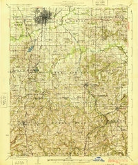
(5)- 1920 Map of Dongola, 1953 Print
 1920 Dongola1953 Print · USGSSouthern Illinois at the close of the 1910s reveals a landscape of river-bottom farms and busy rail junctions. Genealogists can trace family roots through dozens of local landmarks like Beech Grove School, Joppa Junction, and the State Hospital.3 unique versions available
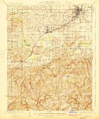
 - 1922 Map of Carbondale
 1922 Carbondale1922 Print · USGSSouthern Illinois in the early 1920s is captured here at the height of its rail-driven rural development. Genealogists can trace family connections through dozens of named rural sites like Stone School, Cottage Home Church, and the Illinois Central corridor.3 unique versions available
 - 1923 Map of Dongola
 1923 Dongola1923 Print · USGSSouthern Illinois in the early twenties reveals a landscape of marshy river bottoms and upland family farms. Researchers can trace ancestral locations through dozens of named rural sites like St Johns Church, Egypt School, and Hoppa Junction.2 unique versions available
 - 1925 Map of Marion
 1925 Marion1925 Print · USGSSouthern Illinois in the mid-twenties was a landscape of coal-country rail hubs and remote ridge-top settlements. Genealogists and historians can trace the network of country schools and churches like Coalbank Springs Church, the industrial footprint of Pilleys Mill, and the rail corridors through Tunnel Hill.3 unique versions available
 - 1925 Map of Harrisburg
 1925 Harrisburg1925 Print · USGSSouthern Illinois coal country is in its prime during the 1920s, showing a landscape of rail-connected mining towns and remote hill settlements. Genealogists can locate dozens of country schools and churches like Mayhew School and Salem Church, alongside industrial landmarks like Wasson Mine No 2.3 unique versions available
End of results
Showing maps 1-5 of 5
Top cities of Johnson County
- Vienna historical maps
- Goreville historical maps
- Cypress historical maps
- New Burnside historical maps
- Buncombe historical maps
- Belknap historical maps
See more
Frequently asked questions
- What are the different types of historical maps available for Johnson County?
- What is the oldest map of Johnson County?
- Where can I purchase historical maps of Johnson County for my home or office?
- Where can I download high-res historical maps of Johnson County?
- Are there historical topographic maps available for Johnson County?
- Is there historical aerial imagery available for Johnson County?
- Where are historical maps of Johnson County sourced from?