1900s (20th Century) Maps of Fox Township, Illinois
Explore 14 historic maps of Fox Township from the 1900s (20th Century). These maps offer a rare glimpse into what life looked like during the 1900s — showing old roads, neighborhoods, homes, and landmarks that have changed or disappeared over time.
Whether you're researching your family's past, planning a metal detecting trip, or studying how Fox Township's landscape evolved across the 1900s, these high-resolution maps are a powerful tool for exploring the history of this region.
- Focus on a specific era: All maps on this page are from the 1900s, giving you a focused view of this time period.
- See what’s changed: Compare century-old streets, trails, and buildings to today's modern landscape using overlays and satellite layers.
- Research with precision: Use these maps for genealogy, historical research, land use analysis, or educational projects.
- View, download, or print: Maps are fully viewable online in high resolution, and can be downloaded or printed for your own records.
Start exploring Fox Township's history through authentic maps from the 1900s. This is your window into the past.
Fox Township, IL maps
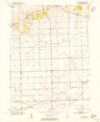
(14)- 1925 Map of Yorkville
 1925 Yorkville1925 Print · USGSKendall County in the mid-twenties shows a landscape of river-valley commerce and a dense network of interurban electric rail lines. Genealogists can locate family-named schoolhouses like Tamarack School and rural hubs such as Platteville and Helmar.2 unique versions available
 - 1948 Map of Sandwich, 1965 Print
 1948 Sandwich1965 Print · USGSThe Fox River valley in the late 1940s is a landscape of established rail towns and deep rural roots. Researchers can trace the Indian Boundary Line or locate family landmarks like French Ch, Oak Mound Cem, and the Sleezer Sch.
 - 1950 Map of Sandwich
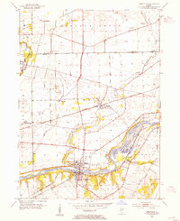
 1950 Sandwich1950 Print · USGSNorthern Illinois prairie and river valleys come alive in the mid-century, following the rail lines of the Chicago Burlington and Quincy. Trace family roots at the Sandwich Fair Grounds or local landmarks like Maramech Hill and State Boys Training School.2 unique versions available
 - 1953 Map of Plattville, 1955 Print
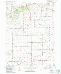
 1953 Plattville1955 Print · USGSKendall County agriculture and rural life are captured here during the early fifties, showing the region's established farm-to-market landscape. Researchers can locate specific community hubs like Helmar, the Emanuel Church, and local schoolhouses like Cross Sch.2 unique versions available
 - 1953 Map of Yorkville, 1955 Print
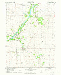
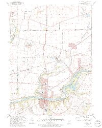
 1953 Yorkville1955 Print · USGSThe Fox River valley in the early 1950s shows the development of Kendall County just as suburban patterns began to reach the prairie. Researchers can trace historic family burial sites at Jericho Cem or locate the site of the Keck Sch (Abandoned) and Bristol (PO and Sta).3 unique versions available
 - 1954 Map of Yorkville, 1959 Print
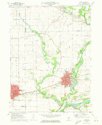
 1954 Yorkville1959 Print · USGSKendall County in the mid-1950s shows a balance between growing riverside towns and an expansive agricultural interior. Genealogists can trace family roots through rural landmarks like Naausay Ch, Jericho Cem, and the long-standing diagonal of the Old Indian Boundary.2 unique versions available
 - 1958 Map of Aurora, 1969 Print
 1958 Aurora1969 Print · USGSNorthern Illinois in the late fifties shows a landscape of powerful river industry and expanding transport corridors. Genealogists and historians can trace the development of Aurora and Joliet or locate sites like the Elwood Ordnance Plant and Starved Rock.3 unique versions available
 - 1961 Map of Aurora
 1961 Aurora1961 Print · USGSNorthern Illinois at the height of the post-war era reveals a landscape of massive industrial works and thriving river towns. Genealogists and historians can trace the paths of the Lincoln Highway or locate long-standing landmarks like the Green River Ordnance Plant and Starved Rock State Park.
 - 1971 Map of Newark, 1973 Print
 1971 Newark1973 Print · USGSKendall and La Salle counties come together at the start of the 1970s, as the river-and-rail corridor supports a string of small settlements. Genealogists can trace family roots at the Millington Newark Cem or locate the old Bushnell School and the community at Lisbon Center.2 unique versions available
 - 1971 Map of Plano, 1973 Print
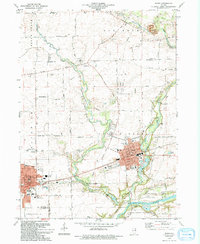
 1971 Plano1973 Print · USGSKendall County's river-and-rail corridor is captured here in the early seventies, showing the growth of Plano and Sandwich. Local historians can trace family landmarks and rural infrastructure, from Plano Cem to the Burlington Northern rail line.
 - 1985 Map of Aurora, 1989 Print
 1985 Aurora1989 Print · USGSNortheastern Illinois is captured in the mid-1980s as suburban growth began to bridge the gap between the Fox River cities and the outer prairies. Researchers can trace the development of Naperville and Aurora or locate rural landmarks like Fairview Cem and the Illinois and Michigan Canal.
 - 1993 Map of Yorkville, 1994 Print
 1993 Yorkville1994 Print · USGSThe Fox River valley in the early nineties shows a landscape of river-front parks and historic transit routes. Genealogists can trace family names at St Patricks Cem and Oak Grove Cem or locate the Glen D Palmer State Game Farm.
 - 1993 Map of Plattville, 1994 Print
 1993 Plattville1994 Print · USGSThe rural prairie of Kendall County is captured here in the early nineties, showing a landscape of established family farms and crossroads communities. Genealogists and local historians can locate Emanuel Cem, Cross Sch, and the historical Chicago Indian Reservation Boundary.
 - 1994 Map of Plano
 1994 Plano1994 Print · USGSKendall County experienced a mix of industrial rail traffic and suburban expansion in the 1990s as towns like Plano and Sandwich grew. Researchers can trace several family-named burial grounds like Welch Cem and Scott Cem or locate the old Burlington Northern line.
End of results
Showing maps 1-14 of 14
Top cities near Fox Township
- Aurora historical maps
- Joliet historical maps
- Batavia historical maps
- Oswego historical maps
- Yorkville historical maps
- North Aurora historical maps
See more
Top neighborhoods of Fox Township
Frequently asked questions
- What are the different types of historical maps available for Fox Township?
- What is the oldest map of Fox Township?
- Where can I purchase historical maps of Fox Township for my home or office?
- Where can I download high-res historical maps of Fox Township?
- Are there historical topographic maps available for Fox Township?
- Is there historical aerial imagery available for Fox Township?
- Where are historical maps of Fox Township sourced from?