1900s (20th Century) Maps of Galesburg, Illinois
Explore 11 historic maps of Galesburg from the 1900s (20th Century). These maps offer a rare glimpse into what life looked like during the 1900s — showing old roads, neighborhoods, homes, and landmarks that have changed or disappeared over time.
Whether you're researching your family's past, planning a metal detecting trip, or studying how Galesburg's landscape evolved across the 1900s, these high-resolution maps are a powerful tool for exploring the history of this region.
- Focus on a specific era: All maps on this page are from the 1900s, giving you a focused view of this time period.
- See what’s changed: Compare century-old streets, trails, and buildings to today's modern landscape using overlays and satellite layers.
- Research with precision: Use these maps for genealogy, historical research, land use analysis, or educational projects.
- View, download, or print: Maps are fully viewable online in high resolution, and can be downloaded or printed for your own records.
Start exploring Galesburg's history through authentic maps from the 1900s. This is your window into the past.
Galesburg, IL maps
(11)- 1925 Map of Galesburg, 1968 Print
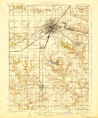
 1925 Galesburg1968 Print · USGSGalesburg and the surrounding Knox County townships appear here as a thriving rail and agricultural center between the world wars. Researchers can trace dozens of rural school sites and early landmarks like Lake Bracken, Orange Chapel, and the East Galesburg Randall PO.2 unique versions available
 - 1927 Map of Galesburg
 1927 Galesburg1927 Print · USGSKnox County is captured in the mid-twenties at its peak as a Midwestern rail hub centered on Galesburg. Local historians can trace dozens of rural school sites like Log City School or explore the early footprints of Knoxville and Abingdon.3 unique versions available
 - 1958 Map of Burlington, 1968 Print
 1958 Burlington1968 Print · USGSThe tri-state river country of Iowa, Illinois, and Missouri is captured here in the mid-fifties, dominated by the Mississippi River and major rail lines. Genealogists and historians can trace the development of river towns like Keokuk or locate the sprawling Iowa Army Ammunition Plant.4 unique versions available
 - 1961 Map of Burlington
 1961 Burlington1961 Print · USGSThe tri-state borderlands along the Mississippi River are captured here during the late fifties and early sixties, showing the vital river-and-rail economy of Iowa, Illinois, and Missouri. Genealogists and historians can trace the development of major hubs like Galesburg and Macomb alongside landmark sites such as the Iowa Ordnance Plant and the historic river town of Nauvoo.
 - 1963 Map of Burlington
 1963 Burlington1963 Print · USGSThe tri-state river country of the Mississippi and Illinois valleys comes alive in this mid-century survey. Genealogists and historians can trace the industrial and academic growth of the region, from the Iowa Ordnance Plant to campuses like Knox College and Western Illinois University.
 - 1982 Map of Galesburg West, 1983 Print
 1982 Galesburg West1983 Print · USGSGalesburg and the surrounding western Illinois prairie appear here in the early eighties as a thriving regional hub of education and rail. Researchers can trace family roots at Linwood Cem or locate former rural landmarks like Utah and the Coldbrook Sch.
 - 1982 Map of Galesburg East, 1983 Print
 1982 Galesburg East1983 Print · USGSKnox County shows its industrial and educational roots in the early eighties as the rail lines of the BURLINGTON NORTHERN meet the urban streets of GALESBURG. Genealogists and historians can trace the grounds of Knox College, St Marys Hospital, and the Swedish Cem.
 - 1985 Map of Galesburg, 1986 Print
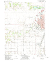
 1985 Galesburg1986 Print · USGSWestern Illinois in the mid-eighties was a landscape of riverfront forests and industrial rail hubs. Genealogists and historians can trace the growth of Galesburg and Monmouth alongside rural landmarks like Stronghurst and the coal operations of the Strip Mine near Canton.2 unique versions available
 - 1989 Map of Galesburg
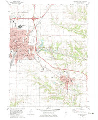
 1989 Galesburg1989 Print · USGSWestern Illinois in the late eighties reveals a landscape of industrial rail hubs and riverfront timberland. Genealogists and historians can trace the routes of the Atchison Topeka and Santa Fe RR through small towns like Stronghurst, London Mills, and Middle Grove (Middlepoint).
 - 1990 Map of Burlington
 1990 Burlington1990 Print · USGSThe tri-state confluence of Iowa, Illinois, and Missouri is mapped here at the end of the twentieth century. Genealogists and historians can trace the riverfront heritage of Burlington, Keokuk, and Fort Madison, or locate sites like the Battle of Athens State Historic Site.2 unique versions available
 - 1996 Map of Galesburg West, 1997 Print
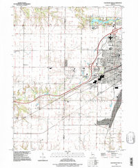 1996 Galesburg West1997 Print · USGSGalesburg was expanding westward in the 1990s as the urban grid reached into the surrounding Knox County farmland. Researchers can trace the layout of Knox College, find numerous family burial sites like Miles Cem, or locate the Galesburg Municipal Airport.
End of results
Showing maps 1-11 of 11
Top cities near Galesburg
- Abingdon historical maps
- Knoxville historical maps
- Ontario historical maps
- Wataga historical maps
- East Galesburg historical maps
- Oneida historical maps
See more
Frequently asked questions
- What are the different types of historical maps available for Galesburg?
- What is the oldest map of Galesburg?
- Where can I purchase historical maps of Galesburg for my home or office?
- Where can I download high-res historical maps of Galesburg?
- Are there historical topographic maps available for Galesburg?
- Is there historical aerial imagery available for Galesburg?
- Where are historical maps of Galesburg sourced from?