1940s Maps of Williamsfield, Illinois
Explore 2 historic maps of Williamsfield from the 1940s. These maps offer a rare glimpse into what life looked like during the 1940s — showing old roads, neighborhoods, homes, and landmarks that have changed or disappeared over time.
Whether you're researching your family's past, planning a metal detecting trip, or studying how Williamsfield's landscape evolved across the 1940s, these high-resolution maps are a powerful tool for exploring the history of this region.
- Focus on a specific era: All maps on this page are from the 1940s, giving you a focused view of this time period.
- See what’s changed: Compare century-old streets, trails, and buildings to today's modern landscape using overlays and satellite layers.
- Research with precision: Use these maps for genealogy, historical research, land use analysis, or educational projects.
- View, download, or print: Maps are fully viewable online in high resolution, and can be downloaded or printed for your own records.
Start exploring Williamsfield's history through authentic maps from the 1940s. This is your window into the past.
Williamsfield, IL maps
(2)- 1941 Map of Maquon, 1961 Print
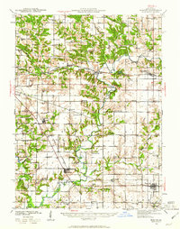 1941 Maquon1961 Print · USGSKnox County's river valleys and rail corridors are captured here in the early 1940s as the local coal and agricultural economies thrived. Researchers can locate dozens of country schools and family landmarks, from Van Gilder Cem to the Knoxville Mine and Union Grove Ch.2 unique versions available
 - 1943 Map of Maquon
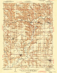 1943 Maquon1943 Print · USGSKnox County's river valleys and coal-rich hills are captured in the early 1940s, showing a landscape defined by the Spoon River. Genealogists and historians can trace numerous rural cemeteries and country schools, from Van Gilder Cem to Center Prairie Sch.2 unique versions available
End of results
Showing maps 1-2 of 2
Top cities near Williamsfield
- Farmington historical maps
- Elmwood historical maps
- Toulon historical maps
- Brimfield historical maps
- Oneida historical maps
- Yates City historical maps
See more
Frequently asked questions
- What are the different types of historical maps available for Williamsfield?
- What is the oldest map of Williamsfield?
- Where can I purchase historical maps of Williamsfield for my home or office?
- Where can I download high-res historical maps of Williamsfield?
- Are there historical topographic maps available for Williamsfield?
- Is there historical aerial imagery available for Williamsfield?
- Where are historical maps of Williamsfield sourced from?