1990s Maps of Lake County, Illinois
Explore 17 historic maps of Lake County from the 1990s. These maps offer a rare glimpse into what life looked like during the 1990s — showing old roads, neighborhoods, homes, and landmarks that have changed or disappeared over time.
Whether you're researching your family's past, planning a metal detecting trip, or studying how Lake County's landscape evolved across the 1990s, these high-resolution maps are a powerful tool for exploring the history of this region.
- Focus on a specific era: All maps on this page are from the 1990s, giving you a focused view of this time period.
- See what’s changed: Compare century-old streets, trails, and buildings to today's modern landscape using overlays and satellite layers.
- Research with precision: Use these maps for genealogy, historical research, land use analysis, or educational projects.
- View, download, or print: Maps are fully viewable online in high resolution, and can be downloaded or printed for your own records.
Start exploring Lake County's history through authentic maps from the 1990s. This is your window into the past.
Lake County, IL maps
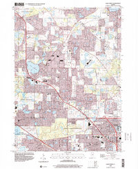
(17)- 1993 Map of Highland Park
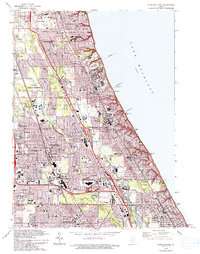 1993 Highland Park1993 Print · USGSThe North Shore suburbs flourish along the Lake Michigan coast in the early nineties as modern expressways intersect with historic rail lines. Genealogists and local historians can trace legacy sites like Fort Sheridan, Lake Forest College, and Deerfield Cem.
 - 1993 Map of Wadsworth
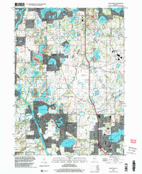
 1993 Wadsworth1993 Print · USGSLake County settlements and the Des Plaines riverfront are captured here in the early nineties as suburban expansion met rural township history. Researchers can trace family roots through St Patricks Cem, identify old school sites like Howe Sch, or locate vanished crossroads at Rosecrans and Fossland.2 unique versions available
 - 1993 Map of Grayslake
 1993 Grayslake1993 Print · USGSLake County was rapidly evolving in the early 1990s, blending established lakefront communities with new suburban growth. Genealogists and local historians can trace family sites at Druce Cemetery and St Joseph Church, or explore the development patterns around Loch Lomond and Hainesville.
 - 1993 Map of Wauconda
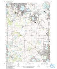
 1993 Wauconda1993 Print · USGSThe Fox River and its glacial lakes defined the Lake County borderlands in the early nineties as residential growth expanded around traditional preserves. Genealogists can trace family names at Fisher Family Cem or locate the old Crown Sch and St Marys Chapel.
 - 1993 Map of Fox Lake
 1993 Fox Lake1993 Print · USGSThe Illinois-Wisconsin border country comes alive in this survey of the Chain O' Lakes during the early nineties. Genealogists and local historians can trace family-named sites like Wray-Imeson Cem or explore the transit history of the Chicago and North Western railroad.
 - 1993 Map of Libertyville
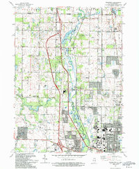
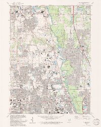
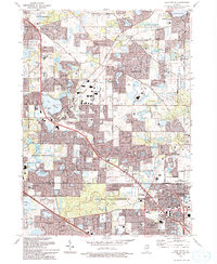
 1993 Libertyville1993 Print · USGSSuburban Lake County enters the nineties as a hub of commerce and transit, from the Des Plaines River to the busy Tri-State Tollway. Researchers can trace local institutions like St Sava Camp, the Naval Training Center, and Carmel High Sch.
 - 1993 Map of Wheeling
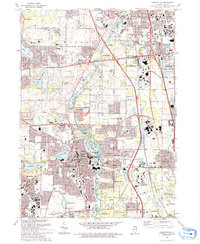
 1993 Wheeling1993 Print · USGSThe northern Chicago suburbs expanded rapidly during the early nineties, centered on the Des Plaines River corridor. Genealogists and local historians can trace school district growth and family plots at Wheeling Cem, St Joseph Sch, and Willow Lawn Cem.2 unique versions available
 - 1993 Map of Zion
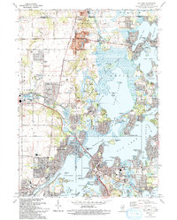
 1993 Zion1993 Print · USGSThe Lake Michigan shoreline at the Wisconsin border is shown here in the early nineties, featuring the transition from industrial Waukegan to the protected dunes of Illinois Beach State Park. Researchers can trace local landmarks like Mount Olivet Memorial Park Cem and the Winthrop Harbor Station.
 - 1993 Map of Lake Zurich
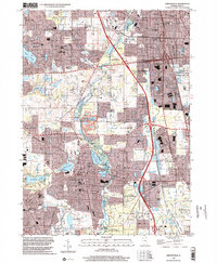
 1993 Lake Zurich1993 Print · USGSThe Lake-Cook county border area is shown during its early 1990s suburban transformation. Genealogists and historians can trace family markers at Fairfield Cem and locate historic community hubs like the Long Grove Ch and Quentin Corners.2 unique versions available
 - 1993 Map of Barrington
 1993 Barrington1993 Print · USGSNorthern Illinois riverside towns and residential enclaves are shown in the early nineties as they expanded around the Fox River. Researchers can trace the rail corridor and locate White Cem, St Ann Sch, and Lake Barrington.
 - 1993 Map of Antioch
 1993 Antioch1993 Print · USGSThe Chain O'Lakes region in the early nineties shows a dense network of suburban growth and glacial water bodies along the Illinois-Wisconsin line. Genealogists and local historians can trace old community markers like Hickory Union Cem, Wedges Corner, and the Petty Sch.
 - 1993 Map of Waukegan
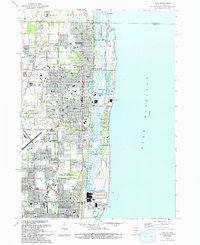
 1993 Waukegan1993 Print · USGSThe Lake County shoreline in the early nineties reveals a dense network of military and civic institutions. Genealogists and historians can trace numerous family-named schools and churches like St Josephs Ch or the vast grounds of the Great Lakes Naval Training Center.
 - 1998 Map of Lake Zurich, 2001 Print
 1998 Lake Zurich2001 Print · USGSLake and Cook counties are shown here during their late-1990s suburban growth, balancing new residential expansion with expansive forest preserves. Genealogists and local researchers can locate landmarks like Fairfield Cem, Mt St Joseph Childrens Home, and Quentin Corners.
 - 1998 Map of Wheeling, 2002 Print
 1998 Wheeling2002 Print · USGSThe north Chicago suburbs of Cook and Lake Counties are shown here during their late-century expansion. Genealogists and local historians can trace the foundations of Wheeling and Half Day while locating landmarks like St Marys Cem and the Hawthorn Center.
 - 1998 Map of Libertyville, 2002 Print
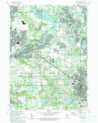
 1998 Libertyville2002 Print · USGSSuburban development and conservation efforts meet in Lake County during the late nineties. Local researchers can trace old landmarks like St Sava Camp, Ascension Cemetery, and the Old School forest preserve near Libertyville.
 - 1998 Map of Waukegan, 2003 Print
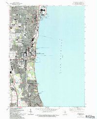
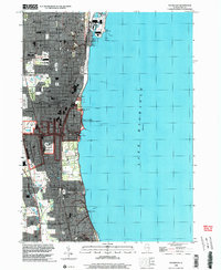 1998 Waukegan2003 Print · USGSThe Lake Michigan shoreline is mapped here in the late 1990s as it transitioned from its industrial roots toward suburban expansion. Trace the layout of the Great Lakes Naval Training Center or locate local landmarks like Skokie Junction and Shimer College.
 - 1998 Map of Wauconda, 2003 Print
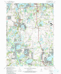
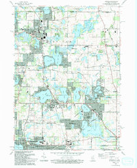
 1998 Wauconda2003 Print · USGSLake County and McHenry County communities are shown here at a peak of suburban growth in the late nineties. Genealogists and local historians can locate legacy sites like Fisher Family Cem, St Marys Chapel, and the Oak Knoll Landing Strip.
End of results
Showing maps 1-17 of 17
Top cities of Lake County
- Waukegan historical maps
- Mundelein historical maps
- North Chicago historical maps
- Gurnee historical maps
- Highland Park historical maps
- Round Lake Beach historical maps
See more
Frequently asked questions
- What are the different types of historical maps available for Lake County?
- What is the oldest map of Lake County?
- Where can I purchase historical maps of Lake County for my home or office?
- Where can I download high-res historical maps of Lake County?
- Are there historical topographic maps available for Lake County?
- Is there historical aerial imagery available for Lake County?
- Where are historical maps of Lake County sourced from?