1920s Maps of Lake County, Illinois
Explore 5 historic maps of Lake County from the 1920s. These maps offer a rare glimpse into what life looked like during the 1920s — showing old roads, neighborhoods, homes, and landmarks that have changed or disappeared over time.
Whether you're researching your family's past, planning a metal detecting trip, or studying how Lake County's landscape evolved across the 1920s, these high-resolution maps are a powerful tool for exploring the history of this region.
- Focus on a specific era: All maps on this page are from the 1920s, giving you a focused view of this time period.
- See what’s changed: Compare century-old streets, trails, and buildings to today's modern landscape using overlays and satellite layers.
- Research with precision: Use these maps for genealogy, historical research, land use analysis, or educational projects.
- View, download, or print: Maps are fully viewable online in high resolution, and can be downloaded or printed for your own records.
Start exploring Lake County's history through authentic maps from the 1920s. This is your window into the past.
Lake County, IL maps
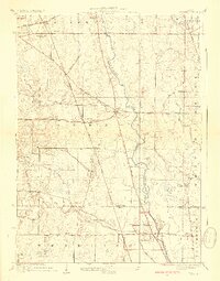
(5)- 1920 Map of Grays Lake
 1920 Grays Lake1920 Print · USGSLake County and the Illinois-Wisconsin borderlands are shown here in the early twenties, when the region was a bustling network of lakeside retreats and rural school districts. Genealogists and historians can trace dozens of family-named landmarks and institutions, including the English Prairie School, St Marys Chapel, and Union Cemetery.3 unique versions available
 - 1923 Map of Grays Lake
 1923 Grays Lake1923 Print · USGSThe glacial lake country of northern Illinois is captured here in the early twenties, just as the resort and rail economy flourished. Genealogists can trace family roots at St Marys Chapel, English Prairie School, and numerous villages like Wauconda and Spring Grove.4 unique versions available
 - 1923 Map of Barrington
 1923 Barrington1923 Print · USGSNorthwest of Chicago in the early twenties, these townships were a network of farm-to-market roads and lakefront resorts. Trace the early boundaries of the Cook County Forest Preserve and find long-gone rural landmarks like Speeck Resort or Quentins Corners.4 unique versions available
 - 1928 Map of Wheeling
 1928 Wheeling1928 Print · USGSNortheastern Illinois appears in the mid-twenties as a landscape of rural schoolhouses and expanding rail lines along the Des Plaines River. Genealogists and local historians can locate early landmarks like Diamond Lake Cemetery, Tripp School, and the settlement of Aptakisic.4 unique versions available
 - 1928 Map of Highland Park
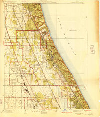 1928 Highland Park1928 Print · USGSThe North Shore was entering a golden age of suburban development and leisure in the late twenties. Trace the expansion of Highland Park and Lake Forest through their numerous estate clubs and historic schools like Lake Forest Academy.4 unique versions available
End of results
Showing maps 1-5 of 5
Top cities of Lake County
- Waukegan historical maps
- Mundelein historical maps
- North Chicago historical maps
- Gurnee historical maps
- Highland Park historical maps
- Round Lake Beach historical maps
See more
Frequently asked questions
- What are the different types of historical maps available for Lake County?
- What is the oldest map of Lake County?
- Where can I purchase historical maps of Lake County for my home or office?
- Where can I download high-res historical maps of Lake County?
- Are there historical topographic maps available for Lake County?
- Is there historical aerial imagery available for Lake County?
- Where are historical maps of Lake County sourced from?