1900s (20th Century) Maps of LaSalle County, Illinois
Explore 82 historic maps of LaSalle County from the 1900s (20th Century). These maps offer a rare glimpse into what life looked like during the 1900s — showing old roads, neighborhoods, homes, and landmarks that have changed or disappeared over time.
Whether you're researching your family's past, planning a metal detecting trip, or studying how LaSalle County's landscape evolved across the 1900s, these high-resolution maps are a powerful tool for exploring the history of this region.
- Focus on a specific era: All maps on this page are from the 1900s, giving you a focused view of this time period.
- See what’s changed: Compare century-old streets, trails, and buildings to today's modern landscape using overlays and satellite layers.
- Research with precision: Use these maps for genealogy, historical research, land use analysis, or educational projects.
- View, download, or print: Maps are fully viewable online in high resolution, and can be downloaded or printed for your own records.
Start exploring LaSalle County's history through authentic maps from the 1900s. This is your window into the past.
LaSalle County, IL maps
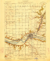
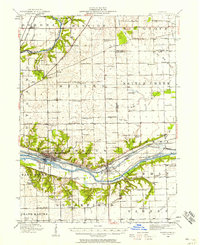
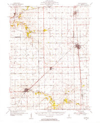
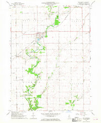
(82)- 1911 Map of La Salle
 1911 La Salle1911 Print · USGSThe Illinois River valley thrived as a hub of rail and river commerce in the early twentieth century. Researchers can trace the development of industrial centers like La Salle and Oglesby, or locate vanished post offices and rural landmarks like Standard Taft PO and St Bedes College.
 - 1913 Map of La Salle
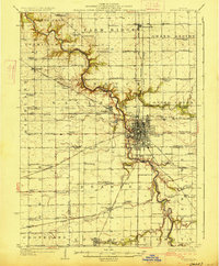
 1913 La Salle1913 Print · USGSThe industrial heart of the Illinois River valley thrives in the early twentieth century, showing the intersection of heavy rail and river trade. Genealogists can trace family homes near St Bedes College or find old post offices like Standard Taft PO and rural stops at Hicks Corners.4 unique versions available
 - 1915 Map of Ottawa
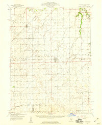
 1915 Ottawa1915 Print · USGSLaSalle County in the early twentieth century centered on the industrial and transit hub of Ottawa at the river's edge. Researchers can trace the path of the Illinois and Michigan Canal or locate local landmarks like Twin Bluffs and Hickory College.7 unique versions available
 - 1916 Map of Marseilles
 1916 Marseilles1916 Print · USGSThe Illinois River valley in the early twentieth century shows a busy network of canals, electric railways, and rural schools. Trace the early layout of Marseilles, the Michigan Canal, and dozens of local landmarks like Norway and the Fox River Academy.4 unique versions available
 - 1925 Map of Streator, 1964 Print
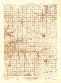
 1925 Streator1964 Print · USGSThe industrial and rail hub of LaSalle and Livingston counties is captured here in the mid-twenties, centered on the Streator river valley. Genealogists can trace rural family life through dozens of named landmarks like Patterson School, St Marys Church, and Moons Point Cemetery.2 unique versions available
 - 1927 Map of Streator
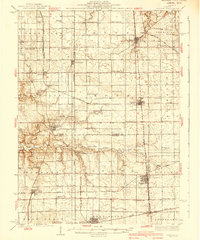
 1927 Streator1927 Print · USGSLaSalle and Livingston Counties appear here during the mid-twenties, when a massive web of railroads supported the bustling hub of Streator. Genealogists and local historians can locate dozens of country schools and churches, from Paddy Ridge School to St Marys Church.2 unique versions available
 - 1934 Map of Wenona
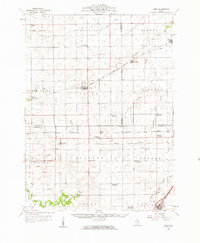
 1934 Wenona1934 Print · USGSThe crossroads of Marshall, Putnam, and La Salle counties are captured here in the mid-1930s, revealing a landscape defined by railroad junctions and rural school districts. Genealogists can locate family-named landmarks like Hullinger Sch and Beckwith Sch, or trace the tracks of the Illinois Central through Wenona.2 unique versions available
 - 1939 Map of Wenona
 1939 Wenona1939 Print · USGSNorth-central Illinois agricultural and rail hubs are captured here in the late 1930s as steam-era infrastructure reached its peak. Researchers can locate dozens of country schools and trace the tracks of the Illinois Central through Wenona and Tonica.2 unique versions available
 - 1940 Map of Marseilles, 1958 Print
 1940 Marseilles1958 Print · USGSLaSalle and Grundy counties appear here during the transition from the canal era to the railway age. Genealogists and local historians can trace family-named school sites like Ness School and Barry School or locate the village of Stavanger.
 - 1946 Map of Ottawa, 1963 Print
 1946 Ottawa1963 Print · USGSOttawa and the Illinois River valley are shown here just after the war, featuring a landscape of industrial riverfronts and deep sandstone canyons. Researchers can locate dozens of country schools like Hickory College or trace the Illinois and Michigan Canal and Starved Rock State Park.2 unique versions available
 - 1947 Map of La Salle, 1958 Print
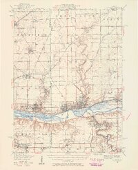 1947 La Salle1958 Print · USGSLa Salle and the Illinois River valley are shown here in the years following the war, as the rail-to-river economy remained in full swing. Local historians can trace the transition from rail to road while locating St Bedes College, Matthiessen Park, and Spring Valley.2 unique versions available
 - 1948 Map of Sandwich, 1965 Print
 1948 Sandwich1965 Print · USGSThe Fox River valley in the late 1940s is a landscape of established rail towns and deep rural roots. Researchers can trace the Indian Boundary Line or locate family landmarks like French Ch, Oak Mound Cem, and the Sleezer Sch.
 - 1950 Map of Sandwich
 1950 Sandwich1950 Print · USGSNorthern Illinois prairie and river valleys come alive in the mid-century, following the rail lines of the Chicago Burlington and Quincy. Trace family roots at the Sandwich Fair Grounds or local landmarks like Maramech Hill and State Boys Training School.2 unique versions available
 - 1951 Map of Earlville, 1952 Print
 1951 Earlville1952 Print · USGSThe rural crossroads of north-central Illinois come to life in this early fifties survey of the area surrounding Earlville and Leland. Genealogists can trace family ties at the Baker Cem or St Clara Cem and locate vanished schoolhouses like Austin Sch.2 unique versions available
 - 1952 Map of Mendota, 1954 Print
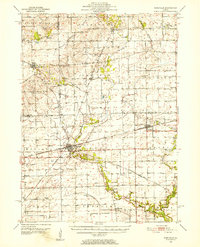
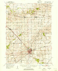 1952 Mendota1954 Print · USGSMendota was a bustling railroad crossroads in the 1950s at the junction of three major lines. Genealogists can trace family roots through numerous country burial grounds and schoolhouses like Holy Cross Cem, Restland Cem, and Schlesinger Sch.3 unique versions available
 - 1955 Map of Minonk, 1956 Print
 1955 Minonk1956 Print · USGSWoodford and Marshall counties at mid-century reveal a thriving rail-and-coal economy across the Illinois prairie. Family researchers and historians can trace lineage at Mennonite Ch, find old Mine Dumps, or locate vanished landmarks like Spring Hill Sch.
 - 1958 Map of Flanagan, 1959 Print
 1958 Flanagan1959 Print · USGSNorth-central Illinois townships during the late fifties show a landscape of thriving rail-side hamlets and rural parish life. Genealogists can locate family landmarks like the Salem Childrens Home, Nigh Chapel, and the Morris Cem near the Vermilion River.2 unique versions available
 - 1958 Map of Odell, 1959 Print
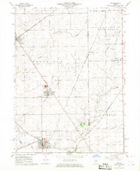
 1958 Odell1959 Print · USGSPrairie townships in Livingston and LaSalle counties show their mid-century transition as rural schools consolidate. Trace family roots at St Patricks Cem, the village of Ransom, or the defunct McGreevy Sch (Abandoned).
 - 1958 Map of Aurora, 1969 Print
 1958 Aurora1969 Print · USGSNorthern Illinois in the late fifties shows a landscape of powerful river industry and expanding transport corridors. Genealogists and historians can trace the development of Aurora and Joliet or locate sites like the Elwood Ordnance Plant and Starved Rock.3 unique versions available
 - 1958 Map of Peoria, 1969 Print
 1958 Peoria1969 Print · USGSCentral Illinois thrived as a hub of education and transport during the late sixties, as the new interstate system began to reshape the prairie. Genealogists and historians can trace local landmarks like Springdale Cem, Bradley University, and the sprawling grounds of Chanute AFB.4 unique versions available
 - 1961 Map of Aurora
 1961 Aurora1961 Print · USGSNorthern Illinois at the height of the post-war era reveals a landscape of massive industrial works and thriving river towns. Genealogists and historians can trace the paths of the Lincoln Highway or locate long-standing landmarks like the Green River Ordnance Plant and Starved Rock State Park.
 - 1961 Map of Peoria
 1961 Peoria1961 Print · USGSCentral Illinois thrived at the intersection of river trade and rail power during the late fifties. Genealogists and local historians can trace the rail networks of the Illinois Central and Wabash, alongside landmarks like Chanute AFB and Weldon Springs State Park.
 - 1963 Map of Peoria
 1963 Peoria1963 Print · USGSCentral Illinois thrived as a rail and highway crossroads during the early sixties, centered on the bustling Illinois River valley. Genealogists and historians can trace the mid-century layout of Peoria, locate the grounds of Chanute Air Force Base, and follow historic lines like the Toledo Peoria and Western Railway.
 - 1966 Map of Ladd, 1968 Print
 1966 Ladd1968 Print · USGSIn the mid-1960s, these Illinois prairie townships remained deeply marked by their coal mining and railroading roots. Researchers can trace the industrial footprint at Ladd, locate family plots at Miners Memorial Cem, or follow the path of the historic Plank Road.2 unique versions available
 - 1966 Map of Troy Grove, 1968 Print
 1966 Troy Grove1968 Print · USGSLaSalle County's agricultural heartland is documented here in the mid-1960s, centered on the river valley and rail corridors. Researchers can locate family landmarks like Crain Cem, the Dimmick Sch, and the industrial Sandpits around Troy Grove.2 unique versions available
Showing maps 1-25 of 82
Top cities of LaSalle County
- Streator historical maps
- Peru historical maps
- LaSalle historical maps
- Marseilles historical maps
- Oglesby historical maps
- Dayton historical maps
See more
Frequently asked questions
- What are the different types of historical maps available for LaSalle County?
- What is the oldest map of LaSalle County?
- Where can I purchase historical maps of LaSalle County for my home or office?
- Where can I download high-res historical maps of LaSalle County?
- Are there historical topographic maps available for LaSalle County?
- Is there historical aerial imagery available for LaSalle County?
- Where are historical maps of LaSalle County sourced from?