1940s Maps of LaSalle County, Illinois
Explore 4 historic maps of LaSalle County from the 1940s. These maps offer a rare glimpse into what life looked like during the 1940s — showing old roads, neighborhoods, homes, and landmarks that have changed or disappeared over time.
Whether you're researching your family's past, planning a metal detecting trip, or studying how LaSalle County's landscape evolved across the 1940s, these high-resolution maps are a powerful tool for exploring the history of this region.
- Focus on a specific era: All maps on this page are from the 1940s, giving you a focused view of this time period.
- See what’s changed: Compare century-old streets, trails, and buildings to today's modern landscape using overlays and satellite layers.
- Research with precision: Use these maps for genealogy, historical research, land use analysis, or educational projects.
- View, download, or print: Maps are fully viewable online in high resolution, and can be downloaded or printed for your own records.
Start exploring LaSalle County's history through authentic maps from the 1940s. This is your window into the past.
LaSalle County, IL maps
(4)- 1940 Map of Marseilles, 1958 Print
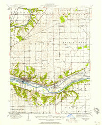 1940 Marseilles1958 Print · USGSLaSalle and Grundy counties appear here during the transition from the canal era to the railway age. Genealogists and local historians can trace family-named school sites like Ness School and Barry School or locate the village of Stavanger.
 - 1946 Map of Ottawa, 1963 Print
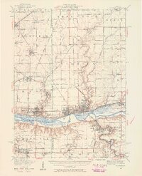
 1946 Ottawa1963 Print · USGSOttawa and the Illinois River valley are shown here just after the war, featuring a landscape of industrial riverfronts and deep sandstone canyons. Researchers can locate dozens of country schools like Hickory College or trace the Illinois and Michigan Canal and Starved Rock State Park.2 unique versions available
 - 1947 Map of La Salle, 1958 Print
 1947 La Salle1958 Print · USGSLa Salle and the Illinois River valley are shown here in the years following the war, as the rail-to-river economy remained in full swing. Local historians can trace the transition from rail to road while locating St Bedes College, Matthiessen Park, and Spring Valley.2 unique versions available
 - 1948 Map of Sandwich, 1965 Print
 1948 Sandwich1965 Print · USGSThe Fox River valley in the late 1940s is a landscape of established rail towns and deep rural roots. Researchers can trace the Indian Boundary Line or locate family landmarks like French Ch, Oak Mound Cem, and the Sleezer Sch.
End of results
Showing maps 1-4 of 4
Top cities of LaSalle County
- Streator historical maps
- Peru historical maps
- LaSalle historical maps
- Marseilles historical maps
- Oglesby historical maps
- Dayton historical maps
See more
Frequently asked questions
- What are the different types of historical maps available for LaSalle County?
- What is the oldest map of LaSalle County?
- Where can I purchase historical maps of LaSalle County for my home or office?
- Where can I download high-res historical maps of LaSalle County?
- Are there historical topographic maps available for LaSalle County?
- Is there historical aerial imagery available for LaSalle County?
- Where are historical maps of LaSalle County sourced from?