1920s Maps of Livingston County, Illinois
Explore 4 historic maps of Livingston County from the 1920s. These maps offer a rare glimpse into what life looked like during the 1920s — showing old roads, neighborhoods, homes, and landmarks that have changed or disappeared over time.
Whether you're researching your family's past, planning a metal detecting trip, or studying how Livingston County's landscape evolved across the 1920s, these high-resolution maps are a powerful tool for exploring the history of this region.
- Focus on a specific era: All maps on this page are from the 1920s, giving you a focused view of this time period.
- See what’s changed: Compare century-old streets, trails, and buildings to today's modern landscape using overlays and satellite layers.
- Research with precision: Use these maps for genealogy, historical research, land use analysis, or educational projects.
- View, download, or print: Maps are fully viewable online in high resolution, and can be downloaded or printed for your own records.
Start exploring Livingston County's history through authentic maps from the 1920s. This is your window into the past.
Livingston County, IL maps
(4)- 1923 Map of Herscher, 1959 Print
 1923 Herscher1959 Print · USGSKankakee and Will Counties in the early twenties show a landscape defined by busy rail junctions and a dense network of rural school districts. Genealogists and researchers can locate family-named landmarks and infrastructure like the Lehigh Stone Co Quarry, Appel Siding, and Essex Center School.2 unique versions available
 - 1925 Map of Herscher
 1925 Herscher1925 Print · USGSKankakee and Grundy counties appear here during the 1920s as a thriving corridor of railroads and rural schools. Genealogists can trace family names through landmarks like Yates School, Clarke City, and the Lehigh Stone Co Quarry.2 unique versions available
 - 1925 Map of Streator, 1964 Print
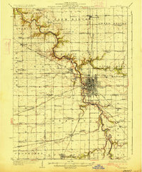
 1925 Streator1964 Print · USGSThe industrial and rail hub of LaSalle and Livingston counties is captured here in the mid-twenties, centered on the Streator river valley. Genealogists can trace rural family life through dozens of named landmarks like Patterson School, St Marys Church, and Moons Point Cemetery.2 unique versions available
 - 1927 Map of Streator
 1927 Streator1927 Print · USGSLaSalle and Livingston Counties appear here during the mid-twenties, when a massive web of railroads supported the bustling hub of Streator. Genealogists and local historians can locate dozens of country schools and churches, from Paddy Ridge School to St Marys Church.2 unique versions available
End of results
Showing maps 1-4 of 4
Top cities of Livingston County
- Dwight historical maps
- Fairbury historical maps
- Chatsworth historical maps
- Forrest historical maps
- Flanagan historical maps
- Odell historical maps
See more
Frequently asked questions
- What are the different types of historical maps available for Livingston County?
- What is the oldest map of Livingston County?
- Where can I purchase historical maps of Livingston County for my home or office?
- Where can I download high-res historical maps of Livingston County?
- Are there historical topographic maps available for Livingston County?
- Is there historical aerial imagery available for Livingston County?
- Where are historical maps of Livingston County sourced from?