1950s Maps of Livingston County, Illinois
Explore 6 historic maps of Livingston County from the 1950s. These maps offer a rare glimpse into what life looked like during the 1950s — showing old roads, neighborhoods, homes, and landmarks that have changed or disappeared over time.
Whether you're researching your family's past, planning a metal detecting trip, or studying how Livingston County's landscape evolved across the 1950s, these high-resolution maps are a powerful tool for exploring the history of this region.
- Focus on a specific era: All maps on this page are from the 1950s, giving you a focused view of this time period.
- See what’s changed: Compare century-old streets, trails, and buildings to today's modern landscape using overlays and satellite layers.
- Research with precision: Use these maps for genealogy, historical research, land use analysis, or educational projects.
- View, download, or print: Maps are fully viewable online in high resolution, and can be downloaded or printed for your own records.
Start exploring Livingston County's history through authentic maps from the 1950s. This is your window into the past.
Livingston County, IL maps
(6)- 1950 Map of Dwight
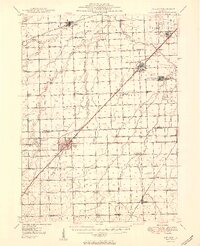 1950 Dwight1950 Print · USGSNortheastern Illinois at mid-century shows a landscape shaped by coal mining and a dense network of rural school districts. Genealogists can trace family footprints through dozens of local landmarks like Round Grove Cemetery, Goodfarm School, and the State Reformatory for Women.2 unique versions available
 - 1957 Map of Colfax, 1958 Print
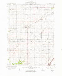
 1957 Colfax1958 Print · USGSCentral Illinois farming country is mapped here during the mid-fifties, showing the vital rail corridors through McLean and Livingston counties. Genealogists can trace family roots at Pleasant Hill Cem, Antioch Cem, and the community of Cooksville.
 - 1958 Map of Flanagan, 1959 Print
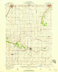
 1958 Flanagan1959 Print · USGSNorth-central Illinois townships during the late fifties show a landscape of thriving rail-side hamlets and rural parish life. Genealogists can locate family landmarks like the Salem Childrens Home, Nigh Chapel, and the Morris Cem near the Vermilion River.2 unique versions available
 - 1958 Map of Odell, 1959 Print
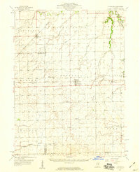
 1958 Odell1959 Print · USGSPrairie townships in Livingston and LaSalle counties show their mid-century transition as rural schools consolidate. Trace family roots at St Patricks Cem, the village of Ransom, or the defunct McGreevy Sch (Abandoned).
 - 1958 Map of Aurora, 1969 Print
 1958 Aurora1969 Print · USGSNorthern Illinois in the late fifties shows a landscape of powerful river industry and expanding transport corridors. Genealogists and historians can trace the development of Aurora and Joliet or locate sites like the Elwood Ordnance Plant and Starved Rock.3 unique versions available
 - 1958 Map of Peoria, 1969 Print
 1958 Peoria1969 Print · USGSCentral Illinois thrived as a hub of education and transport during the late sixties, as the new interstate system began to reshape the prairie. Genealogists and historians can trace local landmarks like Springdale Cem, Bradley University, and the sprawling grounds of Chanute AFB.4 unique versions available
End of results
Showing maps 1-6 of 6
Top cities of Livingston County
- Dwight historical maps
- Fairbury historical maps
- Chatsworth historical maps
- Forrest historical maps
- Flanagan historical maps
- Odell historical maps
See more
Frequently asked questions
- What are the different types of historical maps available for Livingston County?
- What is the oldest map of Livingston County?
- Where can I purchase historical maps of Livingston County for my home or office?
- Where can I download high-res historical maps of Livingston County?
- Are there historical topographic maps available for Livingston County?
- Is there historical aerial imagery available for Livingston County?
- Where are historical maps of Livingston County sourced from?