1980s Maps of Campus, Illinois
Explore 2 historic maps of Campus from the 1980s. These maps offer a rare glimpse into what life looked like during the 1980s — showing old roads, neighborhoods, homes, and landmarks that have changed or disappeared over time.
Whether you're researching your family's past, planning a metal detecting trip, or studying how Campus's landscape evolved across the 1980s, these high-resolution maps are a powerful tool for exploring the history of this region.
- Focus on a specific era: All maps on this page are from the 1980s, giving you a focused view of this time period.
- See what’s changed: Compare century-old streets, trails, and buildings to today's modern landscape using overlays and satellite layers.
- Research with precision: Use these maps for genealogy, historical research, land use analysis, or educational projects.
- View, download, or print: Maps are fully viewable online in high resolution, and can be downloaded or printed for your own records.
Start exploring Campus's history through authentic maps from the 1980s. This is your window into the past.
Campus, IL maps
(2)- 1983 Map of Campus
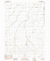 1983 Campus1983 Print · USGSLivingston County farm country is captured here in the early eighties as a network of rail lines and small prairie villages. Genealogists can locate family sites at Sacred Heart Cem or trace the development of Campus, Reddick, and the former mining center of Cardiff.
 - 1985 Map of Ottawa
 1985 Ottawa1985 Print · USGSThe Illinois River valley in the mid-1980s shows a landscape balancing river commerce with sprawling energy and mining operations. Researchers can trace the layout of mining towns like Coal City or find family landmarks such as Oakwood Memorial Cem and Smiths Mound.
End of results
Showing maps 1-2 of 2
Top cities near Campus
- Braidwood historical maps
- Dwight historical maps
- Herscher historical maps
- Gardner historical maps
- Odell historical maps
- Mazon historical maps
See more
Frequently asked questions
- What are the different types of historical maps available for Campus?
- What is the oldest map of Campus?
- Where can I purchase historical maps of Campus for my home or office?
- Where can I download high-res historical maps of Campus?
- Are there historical topographic maps available for Campus?
- Is there historical aerial imagery available for Campus?
- Where are historical maps of Campus sourced from?