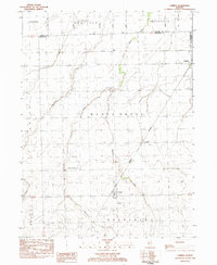
1983 Map of Campus
USGS Topo · Published 1983About this map
Campus and the surrounding prairie of Livingston County are defined by a grid of agricultural land and critical rail corridors in the early 1980s. The Norfolk and Western line anchors the community of Campus, where the Sacred Heart Cem and local grain elevators reflect the town's role as a rural collection point. Further north, the village of Reddick sits at the junction of the Conrail line and the county border, while Cardiff remains a distinct geographic marker south of the railroad tracks.
Find a feature on this map
22 named features on this map. Tap any name to fly to it.
Don’t see what you’re looking for? This feature index may not catch every label — zoom into the map to look around manually.
Map Details
Editions of this 1983 Campus Map
This is the sole edition of this map. No revisions or reprints were ever made.
Other maps of this area

1923 · Herscher
USGS Topo · 1:62,500

1925 · Herscher
USGS Topo · 1:62,500

1944 · Piper City
USGS Topo · 1:48,000

1947 · Piper City
USGS Topo · 1:62,500

1947 · Cullom
USGS Topo · 1:62,500

1948 · Dwight
USGS Topo · 1:62,500

1949 · Cullom
USGS Topo · 1:62,500

1950 · Dwight
USGS Topo · 1:62,500

1958 · Aurora
USGS Topo · 1:250,000

1958 · Peoria
USGS Topo · 1:250,000