1990s Maps of Rooks Creek Township, Illinois
Explore 5 historic maps of Rooks Creek Township from the 1990s. These maps offer a rare glimpse into what life looked like during the 1990s — showing old roads, neighborhoods, homes, and landmarks that have changed or disappeared over time.
Whether you're researching your family's past, planning a metal detecting trip, or studying how Rooks Creek Township's landscape evolved across the 1990s, these high-resolution maps are a powerful tool for exploring the history of this region.
- Focus on a specific era: All maps on this page are from the 1990s, giving you a focused view of this time period.
- See what’s changed: Compare century-old streets, trails, and buildings to today's modern landscape using overlays and satellite layers.
- Research with precision: Use these maps for genealogy, historical research, land use analysis, or educational projects.
- View, download, or print: Maps are fully viewable online in high resolution, and can be downloaded or printed for your own records.
Start exploring Rooks Creek Township's history through authentic maps from the 1990s. This is your window into the past.
Rooks Creek Township, IL maps
(5)- 1990 Map of Peoria
 1990 Peoria1990 Print · USGSCentral Illinois at the start of the nineties reveals a landscape of industrial river towns and sprawling university campuses. Researchers can trace the legacy of major institutions like Chanute Air Force Base and the University of Illinois alongside regional landmarks such as Sand Ridge State Forest.
 - 1998 Map of Flanagan North, 2003 Print
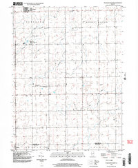
 1998 Flanagan North2003 Print · USGSLivingston County's agricultural heartland is documented here in the late nineties, centered on the communities of Flanagan and Graymont. Local history researchers can trace old family burial grounds like Springer Cem and Earp Cem or the legacy of the Old Railroad Grade.
 - 1998 Map of Southwest Pontiac, 2003 Print
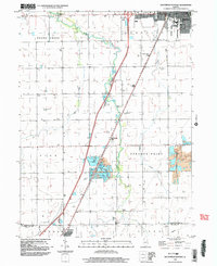 1998 Southwest Pontiac2003 Print · USGSThe rural landscape between Pontiac and Chenoa is captured at the end of the century as the region balanced farming with industrial growth. Local researchers can trace family landmarks like Rooks Creek Cem or the extractive operations at the Ocoya quarries.
 - 1998 Map of Flanagan South, 2003 Print
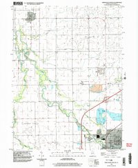
 1998 Flanagan South2003 Print · USGSLivingston County as it appeared in the late 1990s reveals a structured landscape of established townships and quiet crossroads. Genealogists can locate family landmarks like St Josephs Cem and trace rural life around Salem Childrens Home and Waldo.
 - 1998 Map of Northwest Pontiac, 2003 Print
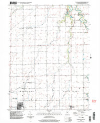
 1998 Northwest Pontiac2003 Print · USGSIn the late nineties, the rural landscape near Pontiac was defined by the winding Vermilion River and a network of prairie townships. Researchers can trace family history through numerous burial sites like Zooks Cem and McMillan Cem, or locate landmarks such as Cornell and the Fairground.
End of results
Showing maps 1-5 of 5
Top cities near Rooks Creek Township
- Streator historical maps
- Pontiac historical maps
- Fairbury historical maps
- El Paso historical maps
- Lexington historical maps
- Chenoa historical maps
See more
Top neighborhoods of Rooks Creek Township
Frequently asked questions
- What are the different types of historical maps available for Rooks Creek Township?
- What is the oldest map of Rooks Creek Township?
- Where can I purchase historical maps of Rooks Creek Township for my home or office?
- Where can I download high-res historical maps of Rooks Creek Township?
- Are there historical topographic maps available for Rooks Creek Township?
- Is there historical aerial imagery available for Rooks Creek Township?
- Where are historical maps of Rooks Creek Township sourced from?