1990s Maps of Oreana, Illinois
Explore 2 historic maps of Oreana from the 1990s. These maps offer a rare glimpse into what life looked like during the 1990s — showing old roads, neighborhoods, homes, and landmarks that have changed or disappeared over time.
Whether you're researching your family's past, planning a metal detecting trip, or studying how Oreana's landscape evolved across the 1990s, these high-resolution maps are a powerful tool for exploring the history of this region.
- Focus on a specific era: All maps on this page are from the 1990s, giving you a focused view of this time period.
- See what’s changed: Compare century-old streets, trails, and buildings to today's modern landscape using overlays and satellite layers.
- Research with precision: Use these maps for genealogy, historical research, land use analysis, or educational projects.
- View, download, or print: Maps are fully viewable online in high resolution, and can be downloaded or printed for your own records.
Start exploring Oreana's history through authentic maps from the 1990s. This is your window into the past.
Oreana, IL maps
(2)- 1998 Map of Forsyth, 2001 Print
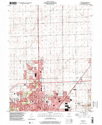 1998 Forsyth2001 Print · USGSMacon County at the close of the twentieth century shows the steady northward growth of the Decatur area into traditional prairie farmland. Genealogists and local historians can trace neighborhood developments near Greens Switch and locate schools like Stephen Decatur High Sch.
 - 1998 Map of Argenta, 2003 Print
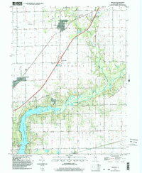 1998 Argenta2003 Print · USGSThe rural landscape of Macon County is captured here at the end of the century, showing the transition from traditional farming communities to the outskirts of the growing city. Genealogists can trace family names at Friends Creek Cem, Cross Cem, and Wheeler Cem, or locate landmarks like Berry Sch.
End of results
Showing maps 1-2 of 2
Top cities near Oreana
- Decatur historical maps
- Clinton historical maps
- Mount Zion historical maps
- Forsyth historical maps
- Maroa historical maps
- Cerro Gordo historical maps
See more
Frequently asked questions
- What are the different types of historical maps available for Oreana?
- What is the oldest map of Oreana?
- Where can I purchase historical maps of Oreana for my home or office?
- Where can I download high-res historical maps of Oreana?
- Are there historical topographic maps available for Oreana?
- Is there historical aerial imagery available for Oreana?
- Where are historical maps of Oreana sourced from?