1970s Maps of Gillespie, Illinois
Explore 2 historic maps of Gillespie from the 1970s. These maps offer a rare glimpse into what life looked like during the 1970s — showing old roads, neighborhoods, homes, and landmarks that have changed or disappeared over time.
Whether you're researching your family's past, planning a metal detecting trip, or studying how Gillespie's landscape evolved across the 1970s, these high-resolution maps are a powerful tool for exploring the history of this region.
- Focus on a specific era: All maps on this page are from the 1970s, giving you a focused view of this time period.
- See what’s changed: Compare century-old streets, trails, and buildings to today's modern landscape using overlays and satellite layers.
- Research with precision: Use these maps for genealogy, historical research, land use analysis, or educational projects.
- View, download, or print: Maps are fully viewable online in high resolution, and can be downloaded or printed for your own records.
Start exploring Gillespie's history through authentic maps from the 1970s. This is your window into the past.
Gillespie, IL maps
(2)- 1974 Map of Gillespie South, 1977 Print
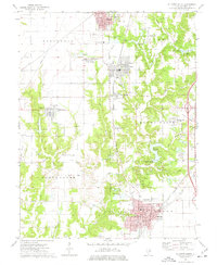 1974 Gillespie South1977 Print · USGSThe Macoupin County coal and rail corridor is captured here in the mid-seventies, showing the close-knit proximity of towns like Gillespie and Benld. Researchers can trace old family burial grounds like Tine Sawyer Cem and defunct rail lines including the Old RR Grade.
 - 1974 Map of Gillespie North, 1977 Print
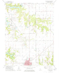 1974 Gillespie North1977 Print · USGSMacoupin County's industrial and agricultural character is on full display in the 1970s, as coal mining and rail transport dominate the landscape. Researchers can trace the legacy of extractive industry at Monterey Mine No 1 and locate historic burial sites like Behme Cem and Prairie Lawn Cem.
End of results
Showing maps 1-2 of 2
Top cities near Gillespie
- Bethalto historical maps
- Litchfield historical maps
- Carlinville historical maps
- Staunton historical maps
- Moro historical maps
- Mount Olive historical maps
See more
Frequently asked questions
- What are the different types of historical maps available for Gillespie?
- What is the oldest map of Gillespie?
- Where can I purchase historical maps of Gillespie for my home or office?
- Where can I download high-res historical maps of Gillespie?
- Are there historical topographic maps available for Gillespie?
- Is there historical aerial imagery available for Gillespie?
- Where are historical maps of Gillespie sourced from?