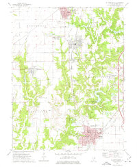
1974 Map of Gillespie South
USGS Topo · Published 1977About this map
Staunton and Gillespie anchor this mid-1970s landscape, reflecting a cluster of Macoupin County towns connected by the Chicago and North Western and Norfolk and Western railroads. The map reveals a transition from industrial-adjacent settlements like Benld and Eagarville to the rural expanses of Gillespie and Dorchester townships. Local history is deeply etched into the terrain through smaller family-named markers and cemeteries such as Tine Sawyer Cem and Kunderburk Cem. Significant water features like the Staunton Reservoir and the winding Cahokia Creek define the eastern and central topography. The inclusion of the Willhoit Landing Strip and various old railroad grades indicates a changing transportation network, where former rail corridors were beginning to give way to smaller private airstrips and modernized infrastructure during this era.
Find a feature on this map
51 named features on this map. Tap any name to fly to it.
Don’t see what you’re looking for? This feature index may not catch every label — zoom into the map to look around manually.
Map Details
Editions of this 1974 Gillespie South Map
This is the sole edition of this map. No revisions or reprints were ever made.
Other maps of this area

1912 · Gillespie
USGS Topo · 1:62,500

1915 · Gillespie
USGS Topo · 1:62,500

1915 · Mount Olive
USGS Topo · 1:62,500

1927 · Edwardsville
USGS Topo · 1:62,500

1932 · Edwardsville
USGS Topo · 1:62,500

1937 · New Douglas
USGS Topo · 1:48,000

1944 · New Douglas
USGS Topo · 1:62,500

1944 · Mount Olive
USGS Topo · 1:62,500

1954 · Worden
USGS Topo · 1:24,000
1954 · Prairietown
USGS Topo · 1:24,000