1930s Maps of Godfrey, Illinois
Explore 4 historic maps of Godfrey from the 1930s. These maps offer a rare glimpse into what life looked like during the 1930s — showing old roads, neighborhoods, homes, and landmarks that have changed or disappeared over time.
Whether you're researching your family's past, planning a metal detecting trip, or studying how Godfrey's landscape evolved across the 1930s, these high-resolution maps are a powerful tool for exploring the history of this region.
- Focus on a specific era: All maps on this page are from the 1930s, giving you a focused view of this time period.
- See what’s changed: Compare century-old streets, trails, and buildings to today's modern landscape using overlays and satellite layers.
- Research with precision: Use these maps for genealogy, historical research, land use analysis, or educational projects.
- View, download, or print: Maps are fully viewable online in high resolution, and can be downloaded or printed for your own records.
Start exploring Godfrey's history through authentic maps from the 1930s. This is your window into the past.
Godfrey, IL maps
(4)- 1930 Map of Jerseyville, 1965 Print
 1930 Jerseyville1965 Print · USGSJersey and Greene Counties are captured here between the world wars, showing a landscape defined by steam rail and one-room schoolhouses. Genealogists can trace the exact locations of Old Kane, the County Farm, and numerous local landmarks like St Marys Sch.2 unique versions available
 - 1933 Map of Jerseyville
 1933 Jerseyville1933 Print · USGSJersey County is captured in the early thirties as a hub of rail activity and rural education. Genealogists can trace family roots through numerous local landmarks like Bethany Ch, Otterville, and the remote Shakerag Sch.2 unique versions available
 - 1933 Map of Saint Charles
 1933 Saint Charles1933 Print · USGSThe confluence of the Missouri and Mississippi rivers in the early thirties reveals a landscape of fertile river bottoms and emerging suburban rail towns. Genealogists and researchers can trace old school districts like Cul de Sac Sch and historic sites such as St Stanislaus Seminary.3 unique versions available
 - 1934 Map of Alton
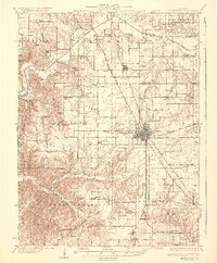
 1934 Alton1934 Print · USGSThe confluence of the Mississippi and Missouri rivers in the early 1930s shows a dense industrial and rail corridor centered on Alton. Genealogists and researchers can trace dozens of rural schools and landmarks like Monticello Seminary, Mt Olive Church, and the City of St Louis Farms.2 unique versions available
End of results
Showing maps 1-4 of 4
Top cities near Godfrey
- Florissant historical maps
- Maryland Heights historical maps
- Granite City historical maps
- Edwardsville historical maps
- Alton historical maps
- Hazelwood historical maps
See more
Top neighborhoods of Godfrey
- Belmont Village historical maps
- North Alton historical maps
- Quatoga Bluff historical maps
- Piasa Hills historical maps
- Riehl historical maps
- Alandale historical maps
See more
Frequently asked questions
- What are the different types of historical maps available for Godfrey?
- What is the oldest map of Godfrey?
- Where can I purchase historical maps of Godfrey for my home or office?
- Where can I download high-res historical maps of Godfrey?
- Are there historical topographic maps available for Godfrey?
- Is there historical aerial imagery available for Godfrey?
- Where are historical maps of Godfrey sourced from?