1980s Maps of Gridley, Illinois
Explore 5 historic maps of Gridley from the 1980s. These maps offer a rare glimpse into what life looked like during the 1980s — showing old roads, neighborhoods, homes, and landmarks that have changed or disappeared over time.
Whether you're researching your family's past, planning a metal detecting trip, or studying how Gridley's landscape evolved across the 1980s, these high-resolution maps are a powerful tool for exploring the history of this region.
- Focus on a specific era: All maps on this page are from the 1980s, giving you a focused view of this time period.
- See what’s changed: Compare century-old streets, trails, and buildings to today's modern landscape using overlays and satellite layers.
- Research with precision: Use these maps for genealogy, historical research, land use analysis, or educational projects.
- View, download, or print: Maps are fully viewable online in high resolution, and can be downloaded or printed for your own records.
Start exploring Gridley's history through authentic maps from the 1980s. This is your window into the past.
Gridley, IL maps
(5)- 1981 Map of Lexington
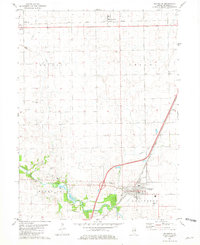 1981 Lexington1981 Print · USGSMcLean County in the early eighties shows a landscape shaped by the Mackinaw River and vital rail lines. Genealogists can locate several family burial sites like Hibbs-Bigger Cem and trace the rural layouts of Meadows and Ballard.
 - 1981 Map of Gridley
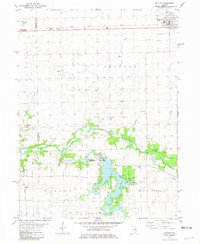 1981 Gridley1981 Print · USGSThe rail-and-river landscape of McLean County comes to life in the early 1980s. Genealogists and local historians can trace family ties at Messer Cem and Wilcox Cem or explore the mid-century recreation sites around Lake Bloomington.
 - 1983 Map of Flanagan SW, 1984 Print
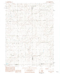 1983 Flanagan SW1984 Print · USGSCentral Illinois farmland at the dawn of the eighties reveals a network of rural townships and private aviation. Trace family sites near Baughman Cem or locate landmarks like the Historical Monument and Pfister Landing Strip.
 - 1984 Map of Flanagan South, 1985 Print
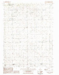 1984 Flanagan South1985 Print · USGSThe northern Illinois prairie in the late seventies is captured here, centered on the townships of Waldo and Nebraska. Researchers can trace rural landmarks from Salem Childrens Home and St Josephs Cem to the Slagel Landing Strip.
 - 1985 Map of Fairbury
 1985 Fairbury1985 Print · USGSCentral Illinois in the mid-1980s reveals a landscape shaped by the Illinois Central Gulf rail network and the Vermilion River basin. Trace the roots of local communities from Fairbury to Pontiac, and locate landmarks like the State Correctional Center and High Chapel.2 unique versions available
End of results
Showing maps 1-5 of 5
Top cities near Gridley
- Normal historical maps
- Pontiac historical maps
- El Paso historical maps
- Minonk historical maps
- Lexington historical maps
- Chenoa historical maps
See more
Frequently asked questions
- What are the different types of historical maps available for Gridley?
- What is the oldest map of Gridley?
- Where can I purchase historical maps of Gridley for my home or office?
- Where can I download high-res historical maps of Gridley?
- Are there historical topographic maps available for Gridley?
- Is there historical aerial imagery available for Gridley?
- Where are historical maps of Gridley sourced from?