
1981 Map of Lexington
USGS Topo · Published 1981About this map
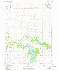
The Mackinaw River winds through the southern portion of this central Illinois landscape, defining the character of Money Creek and Lexington townships. During the early 1980s, the area maintained a distinct agricultural profile, supported by the Toledo Peoria and Western and Illinois Central Gulf railroads. Local infrastructure is marked by the presence of a Gas Storage Area and a Radio Tower near the river, while the town of Lexington serves as the primary population center, featuring a Landing Strip and a Trailer Park.
Find a feature on this map
25 named features on this map. Tap any name to fly to it.
Don’t see what you’re looking for? This feature index may not catch every label — zoom into the map to look around manually.
Map Details
Editions of this 1981 Lexington Map
This is the sole edition of this map. No revisions or reprints were ever made.
Other maps of this area

1926 · Normal
USGS Topo · 1:62,500

1930 · Normal
USGS Topo · 1:62,500

1935 · Pontiac
USGS Topo · 1:62,500

1939 · Pontiac
USGS Topo · 1:62,500

1957 · Colfax
USGS Topo · 1:62,500

1958 · Flanagan
USGS Topo · 1:62,500

1958 · Peoria
USGS Topo · 1:250,000

1961 · Peoria
USGS Topo · 1:250,000

1963 · Peoria
USGS Topo · 1:250,000
1981 · Gridley
USGS Topo · 1:24,000