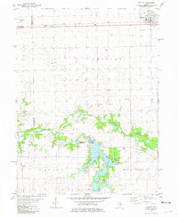
1981 Map of Gridley
USGS Topo · Published 1981About this map
Lake Bloomington dominates the southern landscape of this 1981 quadrangle, serving as a focal point for recreation and community infrastructure with its surrounding Picnic Areas, East Bay Camp, and Camp Heffernan. The terrain is defined by the winding course of the Mackinaw River, which meets Money Creek just south of the Gas Storage Area. To the north, the town of Gridley is positioned along the Toledo Peoria and Western railroad, a corridor that also passes through the small settlement of Enright. The map reveals a deeply rooted rural community, preserved through family and local landmarks such as Messer Cem, Wilcox Cem, and Hinthorn Chapel. This intersection of rail-line commerce and river-valley leisure illustrates the late-twentieth-century character of the McLean and Woodford County border.
Find a feature on this map
34 named features on this map. Tap any name to fly to it.
Don’t see what you’re looking for? This feature index may not catch every label — zoom into the map to look around manually.
Map Details
Editions of this 1981 Gridley Map
This is the sole edition of this map. No revisions or reprints were ever made.
Other maps of this area

1926 · Normal
USGS Topo · 1:62,500

1927 · Danvers
USGS Topo · 1:62,500

1930 · Danvers
USGS Topo · 1:62,500

1930 · Normal
USGS Topo · 1:62,500

1955 · Minonk
USGS Topo · 1:62,500

1958 · Flanagan
USGS Topo · 1:62,500

1958 · Peoria
USGS Topo · 1:250,000

1961 · Peoria
USGS Topo · 1:250,000

1963 · Peoria
USGS Topo · 1:250,000
1970 · El Paso
USGS Topo · 1:24,000