
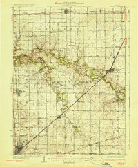
1930 Map of Normal
USGS Topo · Published 1930About this map
The Chicago and Alton railroad cuts diagonally across this Central Illinois landscape, anchoring the development of early rail towns like Lexington, Towanda, and Normal. The survey shows a highly organized agrarian region defined by a dense network of country schoolhouses, such as the Little Red Sch and Pleasant Grove Sch, reflecting the peak of the rural district school system before mid-century consolidation. The northern portion of the map is dominated by the winding path of the Mackinaw River and its timbered breaks, contrasting with the flat prairie topography found in townships like Gridley and Chenoa. Genealogists will find interest in the precise placement of local landmarks like the Town Hall in Money Creek and various family-named schools that served the farming community during this interwar period.
Find a feature on this map
63 named features on this map. Tap any name to fly to it.
Don’t see what you’re looking for? This feature index may not catch every label — zoom into the map to look around manually.
Map Details
Editions of this 1930 Normal Map
2 editions found
Other maps of this area

1926 · Normal
USGS Topo · 1:62,500

1927 · Danvers
USGS Topo · 1:62,500

1930 · Danvers
USGS Topo · 1:62,500

1935 · Pontiac
USGS Topo · 1:62,500

1939 · Pontiac
USGS Topo · 1:62,500

1949 · Mc Lean
USGS Topo · 1:62,500

1951 · McLean
USGS Topo · 1:62,500

1951 · Le Roy
USGS Topo · 1:62,500

1952 · Arrowsmith
USGS Topo · 1:62,500

1955 · Minonk
USGS Topo · 1:62,500