1990s Maps of Lovington, Illinois
Explore 2 historic maps of Lovington from the 1990s. These maps offer a rare glimpse into what life looked like during the 1990s — showing old roads, neighborhoods, homes, and landmarks that have changed or disappeared over time.
Whether you're researching your family's past, planning a metal detecting trip, or studying how Lovington's landscape evolved across the 1990s, these high-resolution maps are a powerful tool for exploring the history of this region.
- Focus on a specific era: All maps on this page are from the 1990s, giving you a focused view of this time period.
- See what’s changed: Compare century-old streets, trails, and buildings to today's modern landscape using overlays and satellite layers.
- Research with precision: Use these maps for genealogy, historical research, land use analysis, or educational projects.
- View, download, or print: Maps are fully viewable online in high resolution, and can be downloaded or printed for your own records.
Start exploring Lovington's history through authentic maps from the 1990s. This is your window into the past.
Lovington, IL maps
(2)- 1998 Map of Cadwell, 2003 Print
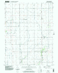 1998 Cadwell2003 Print · USGSMoultrie County at the close of the millennium shows a landscape of enduring rural townships and scattered rail-era settlements. Researchers can pinpoint early community sites like Williamsburg, the Seass Cem, and the path of the Old Railroad Grade.
 - 1999 Map of Lovington, 2003 Print
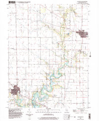 1999 Lovington2003 Print · USGSMoultrie County at the close of the century shows a landscape of steady agricultural communities and protected wetlands. Genealogists and local historians can trace family locations near Lovington and Bethany, or locate rural landmarks like Hewitt Cem and St Isadore Ch.
End of results
Showing maps 1-2 of 2
Top cities near Lovington
- Decatur historical maps
- Mattoon historical maps
- Sullivan historical maps
- Bement historical maps
- Cerro Gordo historical maps
- Long Creek historical maps
See more
Frequently asked questions
- What are the different types of historical maps available for Lovington?
- What is the oldest map of Lovington?
- Where can I purchase historical maps of Lovington for my home or office?
- Where can I download high-res historical maps of Lovington?
- Are there historical topographic maps available for Lovington?
- Is there historical aerial imagery available for Lovington?
- Where are historical maps of Lovington sourced from?