Old Maps of Piatt County, Illinois for Genealogy
Trace your family roots with 111 historic maps of Piatt County. These high-res maps reveal old neighborhoods, homesites, landmarks, and streets — helping you uncover where your ancestors lived and how the area evolved over time.
- Explore historic neighborhoods: Identify where your relatives may have lived in the 1800s or 1900s.
- Compare maps over time: Trace the changes in streets, buildings, and landmarks for multi-generational research.
- Perfect for genealogy & ancestry research: Used by family historians and researchers to map out lineage and migration.
These maps are an incredible resource for exploring your personal connection to Piatt County's past.
Piatt County, IL maps
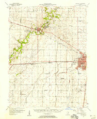
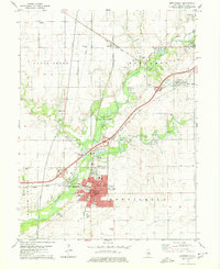
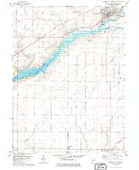
(111)- 1907 Map of Mahomet
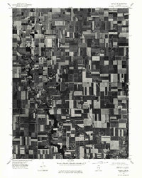
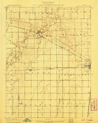 1907 Mahomet1907 Print · USGSChampaign County at the peak of the rail era shows a landscape of burgeoning prairie towns and rural schools. Genealogists and historians can trace family locations near Mahomet, find the precise sites of Bunker Hill School and Fisher School, or follow the Sangamon River.5 unique versions available
 - 1928 Map of Gibson City
 1928 Gibson City1928 Print · USGSCentral Illinois farming life is captured here in the late 1920s, dominated by the major rail junction at Gibson City. Genealogists can locate dozens of country schools like Scotland School and Caledonia School along the Sangamon River.2 unique versions available
 - 1937 Map of Monticello
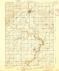
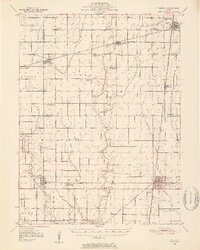
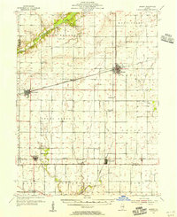
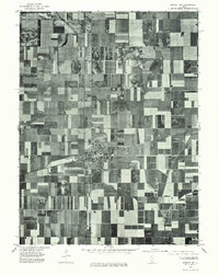
 1937 Monticello1937 Print · USGSIn the mid-1930s, this portion of Piatt and DeWitt counties was a bustling corridor of rail lines and rural school districts. Genealogists can locate family landmarks like Campground Cem or trace the vanished district schools like Watson Sch and Harmony Sch.2 unique versions available
 - 1943 Map of Monticello
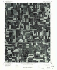
 1943 Monticello1943 Print · USGSCentral Illinois at the height of the Second World War reveals a landscape of thriving rail towns and rural school districts. You can trace the path of the Wabash railroad through White Heath or locate family roots at Kentucky Ch and Greenleaf Cem.2 unique versions available
 - 1950 Map of Tuscola, 1952 Print
 1950 Tuscola1952 Print · USGSMid-century Douglas and Champaign Counties are mapped here at a time when the rural school system was fading into history. Genealogists can trace family roots through numerous markers like Stewart Sch, Macedonia Ch, and Bailey Memorial Cem.4 unique versions available
 - 1952 Map of Arrowsmith
 1952 Arrowsmith1952 Print · USGSAgriculture and the steam-and-diesel rail era meet in this Illinois heartland during the early fifties. Genealogists and historians can trace the foundations of Farmer City and Saybrook while locating rural sites like Prairie Chapel and Payne Cem.2 unique versions available
 - 1955 Map of Bement, 1956 Print
 1955 Bement1956 Print · USGSCentral Illinois prairie life revolved around rail junctions and rural townships in the mid-1950s. Genealogists can trace family footprints at Willow Branch Cem or Asbury Ch, while following the lines of the Wabash and Baltimore and Ohio railroads.2 unique versions available
 - 1957 Map of Gibson City, 1958 Print
 1957 Gibson City1958 Print · USGSMid-century Ford and Champaign Counties are mapped here at the height of the railroad era. Genealogists can trace family names through landmarks like Walker Ch, Oregon Cem, and several schoolhouses like the Mounts Sch or the Blackford Sch.2 unique versions available
 - 1957 Map of Mahomet, 1958 Print
 1957 Mahomet1958 Print · USGSChampaign and its rural neighbors are captured in the late fifties as the city expanded westward toward the Sangamon River. Local researchers can trace family landmarks like Dunkard Cem, the St John Chi, and the University of Illinois Airport.2 unique versions available
 - 1958 Map of Peoria, 1969 Print
 1958 Peoria1969 Print · USGSCentral Illinois thrived as a hub of education and transport during the late sixties, as the new interstate system began to reshape the prairie. Genealogists and historians can trace local landmarks like Springdale Cem, Bradley University, and the sprawling grounds of Chanute AFB.4 unique versions available
 - 1958 Map of Decatur, 1971 Print
 1958 Decatur1971 Print · USGSCentral Illinois in the mid-twentieth century shows a landscape defined by industrial rail hubs and the creation of large reservoirs. Researchers can trace historic corridors like the Penn Central or locate landmarks such as Lincoln Log Cabin State Park and Lake Springfield.3 unique versions available
 - 1961 Map of Peoria
 1961 Peoria1961 Print · USGSCentral Illinois thrived at the intersection of river trade and rail power during the late fifties. Genealogists and local historians can trace the rail networks of the Illinois Central and Wabash, alongside landmarks like Chanute AFB and Weldon Springs State Park.
 - 1961 Map of Decatur
 1961 Decatur1961 Print · USGSCentral Illinois in the late fifties was a bustling corridor of rail lines and prairie commerce centered on the state capital. Genealogists and historians can trace the intricate connections between Springfield, Decatur, and dozens of smaller settlements like Nokomis and Arcola.2 unique versions available
 - 1963 Map of Peoria
 1963 Peoria1963 Print · USGSCentral Illinois thrived as a rail and highway crossroads during the early sixties, centered on the bustling Illinois River valley. Genealogists and historians can trace the mid-century layout of Peoria, locate the grounds of Chanute Air Force Base, and follow historic lines like the Toledo Peoria and Western Railway.
 - 1970 Map of Seymour, 1971 Print
 1970 Seymour1971 Print · USGSEast of the Sangamon River in the early 1970s, this portion of Champaign County shows a landscape defined by the Central Illinois railway and rural townships. Trace family roots at Ingram Cem, St Boniface Ch, and the crossroads of Seymour.2 unique versions available
 - 1970 Map of Mahomet, 1971 Print
 1970 Mahomet1971 Print · USGSMahomet and the Sangamon River valley appear at a point of growth in the early seventies, with new highways and recreation areas taking shape. Trace local family history through Dunkard Cem and Argo Cem, or locate the Covered Bridge at Lake of the Woods.3 unique versions available
 - 1975 Map of Tuscola NW, 1977 Print
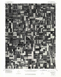 1975 Tuscola NW1977 Print · USGSMid-1970s agricultural patterns and rural settlements are revealed in this aerial survey of the Illinois prairie. Genealogists and land historians can trace property lines and farmstead locations surrounding Ivesdale and the banks of the Kaskaskia River.
 - 1975 Map of Tuscola SW, 1977 Print
 1975 Tuscola SW1977 Print · USGSMid-century Illinois farmland is captured in sharp detail during the autumn of 1975, showing the structured grid of the heartland. Genealogists and local historians can trace the exact footprints of homes and buildings in Atwood and Garrett or follow the banks of the Kaskaskia River.
 - 1975 Map of Bement NE, 1977 Print
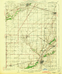
 1975 Bement NE1977 Print · USGSPiatt County farmland and the village of Bement are captured in this mid-1970s aerial study. Researchers can examine the town's residential footprint at Bement and trace the original field patterns along the winding Lake Fork.
 - 1975 Map of Bement SE, 1977 Print
 1975 Bement SE1977 Print · USGSPiatt County farmland is captured in sharp aerial detail during the mid-seventies, showing the precise layout of the central Illinois agricultural grid. Researchers can trace the development of small rural centers like Hammond and Pierson among the fields near Lake and Fork.
 - 1979 Map of Monticello, 1980 Print
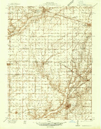
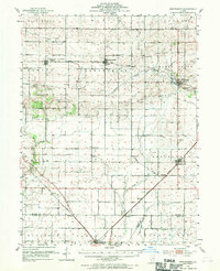
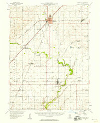
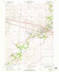
 1979 Monticello1980 Print · USGSMonticello and the Sangamon River valley are captured in the late seventies, showing a hub of rail activity and established rural settlements. Genealogists can trace family heritage through numerous burial sites like Marquiss Cem and Haneline Cem or explore the Illinois Railway Museum.
 - 1979 Map of Farmer City South, 1980 Print
 1979 Farmer City South1980 Print · USGSThe rural landscapes of De Witt and Piatt counties are captured here in the late seventies as the new reservoir at Lake Clinton takes shape. Researchers can trace ancestral sites at Fullerton Church, St. Joseph Cemetery, and McCord Cemetery.
 - 1979 Map of Mansfield, 1980 Print
 1979 Mansfield1980 Print · USGSMansfield and the surrounding Illinois prairie are shown during the late 1970s as a junction for the CONRAIL and NORFOLK AND WESTERN railroads. Researchers can locate family landmarks like Mackey Cem, Bethel Ch, and numerous private runways including the Weidner Landing Field.
 - 1979 Map of Weldon East, 1980 Print
 1979 Weldon East1980 Print · USGSPiatt County farmland in the late seventies is marked by the busy Illinois Central Gulf rail line and quiet rural townships. Genealogists can locate family sites near Weldon, DeLand, or the wooded grounds of Robert Allerton Park.
 - 1983 Map of Hammond
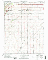
 1983 Hammond1983 Print · USGSThe rural border of Piatt and Moultrie counties is captured here in the early 1980s as a landscape of grid-patterned farms and vital drainage works. Local researchers can locate Hammond Cem, the Jr High Sch in Hammond, and the small settlement of Pierson along the Baltimore and Ohio tracks.
Showing maps 1-25 of 111
Top cities of Piatt County
- Monticello historical maps
- Bement historical maps
- Cerro Gordo historical maps
- Mansfield historical maps
- Hammond historical maps
- De Land historical maps
See more
Frequently asked questions
- What are the different types of historical maps available for Piatt County?
- What is the oldest map of Piatt County?
- Where can I purchase historical maps of Piatt County for my home or office?
- Where can I download high-res historical maps of Piatt County?
- Are there historical topographic maps available for Piatt County?
- Is there historical aerial imagery available for Piatt County?
- Where are historical maps of Piatt County sourced from?