1960s Maps of Percy, Illinois
Explore 3 historic maps of Percy from the 1960s. These maps offer a rare glimpse into what life looked like during the 1960s — showing old roads, neighborhoods, homes, and landmarks that have changed or disappeared over time.
Whether you're researching your family's past, planning a metal detecting trip, or studying how Percy's landscape evolved across the 1960s, these high-resolution maps are a powerful tool for exploring the history of this region.
- Focus on a specific era: All maps on this page are from the 1960s, giving you a focused view of this time period.
- See what’s changed: Compare century-old streets, trails, and buildings to today's modern landscape using overlays and satellite layers.
- Research with precision: Use these maps for genealogy, historical research, land use analysis, or educational projects.
- View, download, or print: Maps are fully viewable online in high resolution, and can be downloaded or printed for your own records.
Start exploring Percy's history through authentic maps from the 1960s. This is your window into the past.
Percy, IL maps
(3)- 1962 Map of Belleville
 1962 Belleville1962 Print · USGSSouthern Illinois in the late fifties reveals a landscape of industrial growth and ancient landmarks before the full expansion of the interstate system. Genealogists can trace family names and rural post offices near Centralia, Salem, and the historic Monks Mound.
 - 1965 Map of Percy, 1966 Print
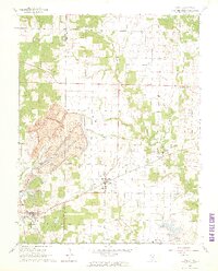 1965 Percy1966 Print · USGSRandolph and Perry Counties are shown in the mid-1960s, just as coal extraction was reshaping the Southern Illinois landscape. Genealogists and historians can trace the massive Strip Mine near Percy or locate family sites like Weitzel Cem and the Lost Prairie Sch.3 unique versions available
 - 1965 Map of Steeleville, 1966 Print
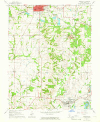 1965 Steeleville1966 Print · USGSRandolph County's coal and rail corridors are frozen in time during the mid-sixties, from the streets of Sparta to the mills of Steeleville. Researchers can trace old family sites at Union Ch and Peace Cem or locate industrial landmarks like the local STRIP MINE.2 unique versions available
End of results
Showing maps 1-3 of 3
Top cities near Percy
- Chester historical maps
- Pinckneyville historical maps
- Sparta historical maps
- Steeleville historical maps
- Marissa historical maps
- Coulterville historical maps
See more
Frequently asked questions
- What are the different types of historical maps available for Percy?
- What is the oldest map of Percy?
- Where can I purchase historical maps of Percy for my home or office?
- Where can I download high-res historical maps of Percy?
- Are there historical topographic maps available for Percy?
- Is there historical aerial imagery available for Percy?
- Where are historical maps of Percy sourced from?