1970s Maps of Ruma, Illinois
Explore 4 historic maps of Ruma from the 1970s. These maps offer a rare glimpse into what life looked like during the 1970s — showing old roads, neighborhoods, homes, and landmarks that have changed or disappeared over time.
Whether you're researching your family's past, planning a metal detecting trip, or studying how Ruma's landscape evolved across the 1970s, these high-resolution maps are a powerful tool for exploring the history of this region.
- Focus on a specific era: All maps on this page are from the 1970s, giving you a focused view of this time period.
- See what’s changed: Compare century-old streets, trails, and buildings to today's modern landscape using overlays and satellite layers.
- Research with precision: Use these maps for genealogy, historical research, land use analysis, or educational projects.
- View, download, or print: Maps are fully viewable online in high resolution, and can be downloaded or printed for your own records.
Start exploring Ruma's history through authentic maps from the 1970s. This is your window into the past.
Ruma, IL maps
(4)- 1970 Map of Ames, 1972 Print
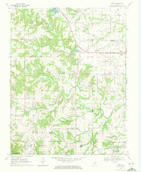 1970 Ames1972 Print · USGSMonroe and Randolph Counties are captured here in the early 1970s, showing a landscape of traditional farmsteads and rural parish life. Researchers can trace family history through sites like St Patrick Sch Cem, Nelson Cem, and the rail corridor of the Gulf Mobile and Ohio.
 - 1970 Map of Prairie Du Rocher, 1972 Print
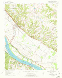 1970 Prairie Du Rocher1972 Print · USGSThe Mississippi River floodplain and limestone bluffs define the Randolph County borderlands around the 1970s. Genealogists and historians can trace rail-side settlements like Prairie du Rocher, the Modoc Rock Shelter National Historic Site, and riverfront sites at Mudds Landing.3 unique versions available
 - 1970 Map of Red Bud, 1972 Print
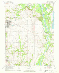 1970 Red Bud1972 Print · USGSRed Bud and the surrounding Horse Prairie are captured here at the start of the 1970s during a period of significant river engineering. Researchers can trace family sites like Brickley Cemetery or follow the Gulf Mobile and Ohio rail line past Trinity School.3 unique versions available
 - 1970 Map of Evansville, 1972 Print
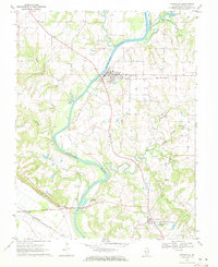 1970 Evansville1972 Print · USGSRandolph County's river valley comes alive in the early seventies as the Kaskaskia River winds past rural settlements and active rail lines. Researchers can trace family history through sites like St Johns Ch, Ellis Grove, and McCormick Cem.2 unique versions available
End of results
Showing maps 1-4 of 4
Top cities near Ruma
- Waterloo historical maps
- Chester historical maps
- Sainte Genevieve historical maps
- Sparta historical maps
- Red Bud historical maps
- New Athens historical maps
See more
Frequently asked questions
- What are the different types of historical maps available for Ruma?
- What is the oldest map of Ruma?
- Where can I purchase historical maps of Ruma for my home or office?
- Where can I download high-res historical maps of Ruma?
- Are there historical topographic maps available for Ruma?
- Is there historical aerial imagery available for Ruma?
- Where are historical maps of Ruma sourced from?