1930s Maps of Fairview Heights, Illinois
Explore 4 historic maps of Fairview Heights from the 1930s. These maps offer a rare glimpse into what life looked like during the 1930s — showing old roads, neighborhoods, homes, and landmarks that have changed or disappeared over time.
Whether you're researching your family's past, planning a metal detecting trip, or studying how Fairview Heights's landscape evolved across the 1930s, these high-resolution maps are a powerful tool for exploring the history of this region.
- Focus on a specific era: All maps on this page are from the 1930s, giving you a focused view of this time period.
- See what’s changed: Compare century-old streets, trails, and buildings to today's modern landscape using overlays and satellite layers.
- Research with precision: Use these maps for genealogy, historical research, land use analysis, or educational projects.
- View, download, or print: Maps are fully viewable online in high resolution, and can be downloaded or printed for your own records.
Start exploring Fairview Heights's history through authentic maps from the 1930s. This is your window into the past.
Fairview Heights, IL maps
(4)- 1931 Map of French Village, 1954 Print
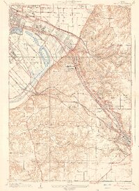
 1931 French Village1954 Print · USGSSt. Clair County's industrial and residential corridors are frozen in time during the early thirties, showing the dense rail networks and coal mining operations of the era. Genealogists can locate family landmarks like Twiss Hill Sch, the Booker T Washington Cemetery, and Gundlach Mines.
 - 1935 Map of French Village
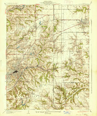
 1935 French Village1935 Print · USGSSt. Clair County's industrial and social landscape in the 1930s is revealed through its dense network of coal mines, electric railways, and emerging suburbs. Trace early settlements and institutions like French Village, St Henry College, and the New St Clair Mine.2 unique versions available
 - 1937 Map of Collinsville
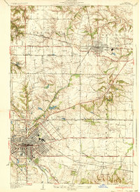
 1937 Collinsville1937 Print · USGSSouthwestern Illinois thrives in the mid-1930s as a hub of rail traffic and coal-country commerce. Genealogists and local historians can trace family locations near Chinatown, Donkville, and numerous country schools like Bethel Sch or Spring Valley Sch.2 unique versions available
 - 1937 Map of O'Fallon
 1937 O'Fallon1937 Print · USGSSt. Clair County's coal and rail landscape is on full display during the late 1930s. Genealogists and historians can trace rail depots like Shiloh Sta, local mines including St Ellen Mine, and numerous country schools such as Whiteside Sch.2 unique versions available
End of results
Showing maps 1-4 of 4
Top cities near Fairview Heights
- St. Louis historical maps
- Belleville historical maps
- O'Fallon historical maps
- Granite City historical maps
- Edwardsville historical maps
- Collinsville historical maps
See more
Top neighborhoods of Fairview Heights
- Union Hill historical maps
- French Village historical maps
- Capitol Oaks historical maps
- Crossroads historical maps
- Furman historical maps
Frequently asked questions
- What are the different types of historical maps available for Fairview Heights?
- What is the oldest map of Fairview Heights?
- Where can I purchase historical maps of Fairview Heights for my home or office?
- Where can I download high-res historical maps of Fairview Heights?
- Are there historical topographic maps available for Fairview Heights?
- Is there historical aerial imagery available for Fairview Heights?
- Where are historical maps of Fairview Heights sourced from?