1960s Maps of Marissa, Illinois
Explore 3 historic maps of Marissa from the 1960s. These maps offer a rare glimpse into what life looked like during the 1960s — showing old roads, neighborhoods, homes, and landmarks that have changed or disappeared over time.
Whether you're researching your family's past, planning a metal detecting trip, or studying how Marissa's landscape evolved across the 1960s, these high-resolution maps are a powerful tool for exploring the history of this region.
- Focus on a specific era: All maps on this page are from the 1960s, giving you a focused view of this time period.
- See what’s changed: Compare century-old streets, trails, and buildings to today's modern landscape using overlays and satellite layers.
- Research with precision: Use these maps for genealogy, historical research, land use analysis, or educational projects.
- View, download, or print: Maps are fully viewable online in high resolution, and can be downloaded or printed for your own records.
Start exploring Marissa's history through authentic maps from the 1960s. This is your window into the past.
Marissa, IL maps
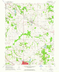
(3)- 1962 Map of Belleville
 1962 Belleville1962 Print · USGSSouthern Illinois in the late fifties reveals a landscape of industrial growth and ancient landmarks before the full expansion of the interstate system. Genealogists can trace family names and rural post offices near Centralia, Salem, and the historic Monks Mound.
 - 1964 Map of St. Libory, 1966 Print
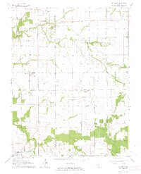 1964 St. Libory1966 Print · USGSSt. Clair and Washington Counties are shown here in the mid-1960s, documenting a landscape of rural hamlets and farming townships. Researchers can trace family sites near Darmstadt Cem, the Johannisburg Sch, and the original settlement at Old Marissa.2 unique versions available
 - 1965 Map of Tilden, 1966 Print
 1965 Tilden1966 Print · USGSSouthwestern Illinois was a critical rail and energy hub in the 1960s, shaped by three major railroad lines and an emerging aviation presence. Local historians can trace the development of Sparta and Tilden alongside landmarks like St Johns Ch and the Caledonia Cemetery.2 unique versions available
End of results
Showing maps 1-3 of 3
Top cities near Marissa
- Belleville historical maps
- Sparta historical maps
- Freeburg historical maps
- Smithton historical maps
- Red Bud historical maps
- New Athens historical maps
See more
Top neighborhoods of Marissa
Frequently asked questions
- What are the different types of historical maps available for Marissa?
- What is the oldest map of Marissa?
- Where can I purchase historical maps of Marissa for my home or office?
- Where can I download high-res historical maps of Marissa?
- Are there historical topographic maps available for Marissa?
- Is there historical aerial imagery available for Marissa?
- Where are historical maps of Marissa sourced from?