1940s Maps of Marissa, Illinois
Explore 2 historic maps of Marissa from the 1940s. These maps offer a rare glimpse into what life looked like during the 1940s — showing old roads, neighborhoods, homes, and landmarks that have changed or disappeared over time.
Whether you're researching your family's past, planning a metal detecting trip, or studying how Marissa's landscape evolved across the 1940s, these high-resolution maps are a powerful tool for exploring the history of this region.
- Focus on a specific era: All maps on this page are from the 1940s, giving you a focused view of this time period.
- See what’s changed: Compare century-old streets, trails, and buildings to today's modern landscape using overlays and satellite layers.
- Research with precision: Use these maps for genealogy, historical research, land use analysis, or educational projects.
- View, download, or print: Maps are fully viewable online in high resolution, and can be downloaded or printed for your own records.
Start exploring Marissa's history through authentic maps from the 1940s. This is your window into the past.
Marissa, IL maps
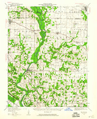
(2)- 1940 Map of Okawville, 1958 Print
 1940 Okawville1958 Print · USGSSouthwestern Illinois at the start of the 1940s remains a landscape of tight-knit farming hamlets and river-bottom wetlands. Researchers can trace the heritage of German settlements and rail stops from St Libory and Darmstadt to the mineral springs area of Okawville.
 - 1942 Map of Baldwin, 1960 Print
 1942 Baldwin1960 Print · USGSMid-century southwestern Illinois reveals a landscape of river-bend settlements and extensive rail networks. Genealogists can locate many local landmarks like Jordan Grove School, the Mobile and Ohio rail line, and the village of Evansville along the Kaskaskia River.
End of results
Showing maps 1-2 of 2
Top cities near Marissa
- Belleville historical maps
- Sparta historical maps
- Freeburg historical maps
- Smithton historical maps
- Red Bud historical maps
- New Athens historical maps
See more
Top neighborhoods of Marissa
Frequently asked questions
- What are the different types of historical maps available for Marissa?
- What is the oldest map of Marissa?
- Where can I purchase historical maps of Marissa for my home or office?
- Where can I download high-res historical maps of Marissa?
- Are there historical topographic maps available for Marissa?
- Is there historical aerial imagery available for Marissa?
- Where are historical maps of Marissa sourced from?