
1940 Map of Okawville
USGS Topo · Published 1958About this map
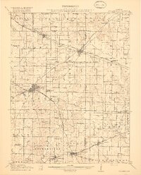
The Kaskaskia River snakes across this Southwestern Illinois landscape, defining the boundaries between St. Clair, Clinton, and Washington counties. This 1940 revision reflects a rural economy deeply tied to the river and the Louisville & Nashville RR, which serves as the primary artery for towns like Okawville and New Memphis Sta. The map reveals a dense network of German-settled farming communities and hamlets, many established in the mid-19th century.
Find a feature on this map
60 named features on this map. Tap any name to fly to it.
Don’t see what you’re looking for? This feature index may not catch every label — zoom into the map to look around manually.
Map Details
Editions of this 1940 Okawville Map
This is the sole edition of this map. No revisions or reprints were ever made.
Other maps of this area

1906 · Breese
USGS Topo · 1:62,500

1907 · Breese
USGS Topo · 1:62,500

1907 · Belleville
USGS Topo · 1:62,500

1910 · Carlyle
USGS Topo · 1:62,500

1910 · Okawville
USGS Topo · 1:62,500

1912 · New Athens
USGS Topo · 1:62,500

1912 · Baldwin
USGS Topo · 1:62,500

1914 · Baldwin
USGS Topo · 1:62,500

1914 · Coulterville
USGS Topo · 1:62,500
1917 · Coulterville
USGS Topo · 1:62,500