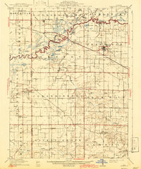
1910 Map of Okawville
USGS Topo · Published 1943About this map
The Kaskaskia River snakes across this landscape, forming a complex boundary between St. Clair, Clinton, and Washington counties. This map captures the area following a 1940 culture revision, showing the transition from river-bottom oxbows like Queens Lake and Horseshoe Lake to the organized agricultural grid of the surrounding townships. The L & N RR provides a critical east-west corridor, serving the primary hub of Okawville and smaller stops like New Memphis Sta and Venedy Station.
Find a feature on this map
54 named features on this map. Tap any name to fly to it.
Don’t see what you’re looking for? This feature index may not catch every label — zoom into the map to look around manually.
Map Details
Editions of this 1910 Okawville Map
2 editions found
Other maps of this area

1906 · Breese
USGS Topo · 1:62,500

1907 · Breese
USGS Topo · 1:62,500

1907 · Belleville
USGS Topo · 1:62,500

1910 · Carlyle
USGS Topo · 1:62,500

1910 · Okawville
USGS Topo · 1:62,500

1912 · New Athens
USGS Topo · 1:62,500

1912 · Baldwin
USGS Topo · 1:62,500

1914 · Baldwin
USGS Topo · 1:62,500

1914 · Coulterville
USGS Topo · 1:62,500

1917 · Coulterville
USGS Topo · 1:62,500