1990s Maps of Smithton, Illinois
Explore 4 historic maps of Smithton from the 1990s. These maps offer a rare glimpse into what life looked like during the 1990s — showing old roads, neighborhoods, homes, and landmarks that have changed or disappeared over time.
Whether you're researching your family's past, planning a metal detecting trip, or studying how Smithton's landscape evolved across the 1990s, these high-resolution maps are a powerful tool for exploring the history of this region.
- Focus on a specific era: All maps on this page are from the 1990s, giving you a focused view of this time period.
- See what’s changed: Compare century-old streets, trails, and buildings to today's modern landscape using overlays and satellite layers.
- Research with precision: Use these maps for genealogy, historical research, land use analysis, or educational projects.
- View, download, or print: Maps are fully viewable online in high resolution, and can be downloaded or printed for your own records.
Start exploring Smithton's history through authentic maps from the 1990s. This is your window into the past.
Smithton, IL maps
(4)- 1990 Map of Millstadt, 1991 Print
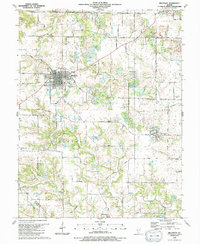 1990 Millstadt1991 Print · USGSThe village of Millstadt and its surrounding farmsteads are shown here as they appeared in the 1990s. Researchers can trace the layout of small settlements like Floraville and Bohleysville or locate family burial sites at Stein-Nagel Cem.
 - 1990 Map of New Athens West, 1991 Print
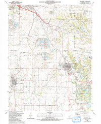
 1990 New Athens West1991 Print · USGSThe riverine corridor of the Kaskaskia River and the rural plains of Prairie Du Long define this landscape during the early nineties. Researchers can trace numerous family-named burial sites and historic schoolhouses like the Grange Hall School and Hecker Cem.
 - 1990 Map of Paderborn, 1991 Print
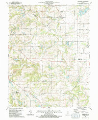 1990 Paderborn1991 Print · USGSSouthwestern Illinois farm country comes into focus in the 1990s as it appeared before suburban expansion reached these rural townships. Genealogists can trace family names through sites like Martini Cem, St Michaels Ch, and the old Burksville Station settlement.
 - 1990 Map of Freeburg, 1991 Print
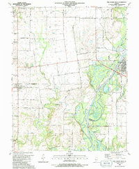
 1990 Freeburg1991 Print · USGSFreeburg and Smithton are captured during a period of coal mining and railway operations in St. Clair County. Genealogists and local historians can trace family roots through numerous burial sites like Wilderman Cem or locate industrial markers such as the Red Ray Mine and the Illinois Central Gulf Railroad.
End of results
Showing maps 1-4 of 4
Top cities near Smithton
- St. Louis historical maps
- Belleville historical maps
- O'Fallon historical maps
- Cahokia Heights historical maps
- East Saint Louis historical maps
- East St. Louis historical maps
See more
Frequently asked questions
- What are the different types of historical maps available for Smithton?
- What is the oldest map of Smithton?
- Where can I purchase historical maps of Smithton for my home or office?
- Where can I download high-res historical maps of Smithton?
- Are there historical topographic maps available for Smithton?
- Is there historical aerial imagery available for Smithton?
- Where are historical maps of Smithton sourced from?