1960s Maps of Harrisburg, Illinois
Explore 6 historic maps of Harrisburg from the 1960s. These maps offer a rare glimpse into what life looked like during the 1960s — showing old roads, neighborhoods, homes, and landmarks that have changed or disappeared over time.
Whether you're researching your family's past, planning a metal detecting trip, or studying how Harrisburg's landscape evolved across the 1960s, these high-resolution maps are a powerful tool for exploring the history of this region.
- Focus on a specific era: All maps on this page are from the 1960s, giving you a focused view of this time period.
- See what’s changed: Compare century-old streets, trails, and buildings to today's modern landscape using overlays and satellite layers.
- Research with precision: Use these maps for genealogy, historical research, land use analysis, or educational projects.
- View, download, or print: Maps are fully viewable online in high resolution, and can be downloaded or printed for your own records.
Start exploring Harrisburg's history through authentic maps from the 1960s. This is your window into the past.
Harrisburg, IL maps
(6)- 1961 Map of Paducah
 1961 Paducah1961 Print · USGSThe Lower Ohio Valley at mid-century is a landscape defined by its great rivers and newly formed reservoirs. Researchers can trace the riverfronts of Paducah and Metropolis, or locate smaller settlements like Old Shawneetown and Cave in Rock along the banks.2 unique versions available
 - 1961 Map of Harrisburg, 1962 Print
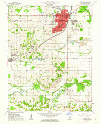 1961 Harrisburg1962 Print · USGSSaline County industry and rural life intersect in the early sixties as coal mining shapes the landscape around Harrisburg. Genealogists and historians can locate numerous family burial grounds like Moore-Vinson Cem and rural centers such as Carrier Mills and Ledford.2 unique versions available
 - 1961 Map of Harrisburg, 1965 Print
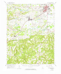 1961 Harrisburg1965 Print · USGSSouthern Illinois coal country and forest lands meet in the early sixties as the rail networks of the New York Central serve a landscape of active mines. Researchers can locate family cemeteries and vanished stops like Dykersburg, Newcastle, and the Sahara Mine No 16 Cem.
 - 1963 Map of Galatia, 1964 Print
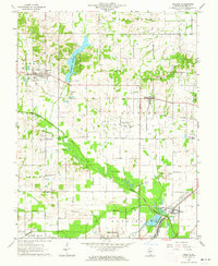 1963 Galatia1964 Print · USGSSaline County’s industrial and rural landscape is clearly etched in the early 1960s, showing a region bustling with oil extraction and rail transport. Researchers can trace family roots through numerous landmarks like Masonic Cem, Bethel Creek Ch, and the settlement of Muddy.2 unique versions available
 - 1963 Map of Galatia, 1966 Print
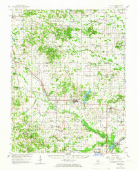 1963 Galatia1966 Print · USGSSouthern Illinois in the early sixties was a landscape defined by coal, oil, and the rails of the Illinois Central. Genealogists can trace family roots through numerous remote burial grounds like Old Ruff Cem and Masonic Cem, or locate landmarks such as Tate Chapel and Harco.2 unique versions available
 - 1964 Map of Paducah
 1964 Paducah1964 Print · USGSThe river-and-rail corridor of Southern Illinois and Western Kentucky is captured here during the height of the mid-century industrial era. Genealogists and researchers can trace local landmarks across several counties, from the rail yards of Paducah to the waters of Crab Orchard Lake and Kentucky Reservoir.2 unique versions available
End of results
Showing maps 1-6 of 6
Top cities near Harrisburg
- Eldorado historical maps
- Carrier Mills historical maps
- Norris City historical maps
- Galatia historical maps
- Equality historical maps
- Thompsonville historical maps
See more
Top neighborhoods of Harrisburg
- Dorris Heights historical maps
- Dorrisville historical maps
- Garden Heights historical maps
- Gaskins City historical maps
- Buena Vista historical maps
Frequently asked questions
- What are the different types of historical maps available for Harrisburg?
- What is the oldest map of Harrisburg?
- Where can I purchase historical maps of Harrisburg for my home or office?
- Where can I download high-res historical maps of Harrisburg?
- Are there historical topographic maps available for Harrisburg?
- Is there historical aerial imagery available for Harrisburg?
- Where are historical maps of Harrisburg sourced from?