1970s Maps of Rushville, Illinois
Explore 2 historic maps of Rushville from the 1970s. These maps offer a rare glimpse into what life looked like during the 1970s — showing old roads, neighborhoods, homes, and landmarks that have changed or disappeared over time.
Whether you're researching your family's past, planning a metal detecting trip, or studying how Rushville's landscape evolved across the 1970s, these high-resolution maps are a powerful tool for exploring the history of this region.
- Focus on a specific era: All maps on this page are from the 1970s, giving you a focused view of this time period.
- See what’s changed: Compare century-old streets, trails, and buildings to today's modern landscape using overlays and satellite layers.
- Research with precision: Use these maps for genealogy, historical research, land use analysis, or educational projects.
- View, download, or print: Maps are fully viewable online in high resolution, and can be downloaded or printed for your own records.
Start exploring Rushville's history through authentic maps from the 1970s. This is your window into the past.
Rushville, IL maps
(2)- 1975 Map of Rushville SE, 1976 Print
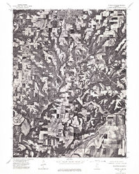 1975 Rushville SE1976 Print · USGSSchuyler County farmland and the southern outskirts of Rushville are captured in high detail during the mid-seventies. Trace the winding course of the La Moine River and examine the precise layout of local timber and farm fields.
 - 1975 Map of Rushville NE, 1976 Print
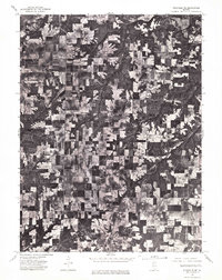 1975 Rushville NE1976 Print · USGSSchuyler County farmland is captured in sharp aerial detail during the mid-seventies, showing the rural landscape between Littleton and Rushville. Researchers can trace old property lines and the wooded breaks of Sugar Creek.
End of results
Showing maps 1-2 of 2
Top cities near Rushville
- Beardstown historical maps
- Mount Sterling historical maps
- Astoria historical maps
- Bluff Springs historical maps
- Vermont historical maps
- Industry historical maps
See more
Frequently asked questions
- What are the different types of historical maps available for Rushville?
- What is the oldest map of Rushville?
- Where can I purchase historical maps of Rushville for my home or office?
- Where can I download high-res historical maps of Rushville?
- Are there historical topographic maps available for Rushville?
- Is there historical aerial imagery available for Rushville?
- Where are historical maps of Rushville sourced from?