1920s Maps of Scott County, Illinois
Explore 6 historic maps of Scott County from the 1920s. These maps offer a rare glimpse into what life looked like during the 1920s — showing old roads, neighborhoods, homes, and landmarks that have changed or disappeared over time.
Whether you're researching your family's past, planning a metal detecting trip, or studying how Scott County's landscape evolved across the 1920s, these high-resolution maps are a powerful tool for exploring the history of this region.
- Focus on a specific era: All maps on this page are from the 1920s, giving you a focused view of this time period.
- See what’s changed: Compare century-old streets, trails, and buildings to today's modern landscape using overlays and satellite layers.
- Research with precision: Use these maps for genealogy, historical research, land use analysis, or educational projects.
- View, download, or print: Maps are fully viewable online in high resolution, and can be downloaded or printed for your own records.
Start exploring Scott County's history through authentic maps from the 1920s. This is your window into the past.
Scott County, IL maps
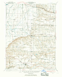
(6)- 1924 Map of Winchester
 1924 Winchester1924 Print · USGSScott and Morgan counties are shown here during the early twenties as a thriving network of small-town rail stops and rural schools. Genealogists can locate dozens of local landmarks like Oak Grove School, Seminary School, and the junction at Winchester.3 unique versions available
 - 1924 Map of Griggsville, 1959 Print
 1924 Griggsville1959 Print · USGSPike and Scott counties are captured during the mid-1920s as the Illinois River and Wabash RR defined local commerce. Researchers can trace rural life through dozens of named landmarks like Brush College School, Bethel Church, and Sleight Pond.2 unique versions available
 - 1926 Map of Griggsville
 1926 Griggsville1926 Print · USGSThe Illinois River valley in the 1920s is captured here at the height of its rail-and-river economy. Genealogists and historians can trace dozens of rural schools and landmarks including Brush College School, Bethel Church, and the Wabash RR corridor.2 unique versions available
 - 1926 Map of Winchester
 1926 Winchester1926 Print · USGSScott and Morgan counties are shown in the mid-twenties, revealing a landscape of small agricultural villages and decentralized country schools. Genealogists can trace family footprints near Strawns Grove School, the Poor Farm, or the rail depot at Alsey.
 - 1928 Map of Meredosia, 1958 Print
 1928 Meredosia1958 Print · USGSThe Illinois River valley in the late 1920s was a bustling corridor of river locks, pumping stations, and rail lines. Genealogists and local historians can trace family roots through numerous rural landmarks like Ham Sch, Reich Landing, and the Perry Spring's Sta rail stop.2 unique versions available
 - 1929 Map of Arenzville, 1969 Print
 1929 Arenzville1969 Print · USGSThe fertile bottomlands of Cass and Morgan Counties are seen here in the late twenties, defined by a dense grid of family farms and rural schools. Genealogists can locate specific landmarks like the Neelyville PO, St Peters Ch, and Jersey College Sch.2 unique versions available
End of results
Showing maps 1-6 of 6
Top cities of Scott County
- Winchester historical maps
- Bluffs historical maps
- Manchester historical maps
- Alsey historical maps
- Glasgow historical maps
- Naples historical maps
See more
Frequently asked questions
- What are the different types of historical maps available for Scott County?
- What is the oldest map of Scott County?
- Where can I purchase historical maps of Scott County for my home or office?
- Where can I download high-res historical maps of Scott County?
- Are there historical topographic maps available for Scott County?
- Is there historical aerial imagery available for Scott County?
- Where are historical maps of Scott County sourced from?