1990s Maps of Scott County, Illinois
Explore 3 historic maps of Scott County from the 1990s. These maps offer a rare glimpse into what life looked like during the 1990s — showing old roads, neighborhoods, homes, and landmarks that have changed or disappeared over time.
Whether you're researching your family's past, planning a metal detecting trip, or studying how Scott County's landscape evolved across the 1990s, these high-resolution maps are a powerful tool for exploring the history of this region.
- Focus on a specific era: All maps on this page are from the 1990s, giving you a focused view of this time period.
- See what’s changed: Compare century-old streets, trails, and buildings to today's modern landscape using overlays and satellite layers.
- Research with precision: Use these maps for genealogy, historical research, land use analysis, or educational projects.
- View, download, or print: Maps are fully viewable online in high resolution, and can be downloaded or printed for your own records.
Start exploring Scott County's history through authentic maps from the 1990s. This is your window into the past.
Scott County, IL maps
(3)- 1990 Map of Meredosia
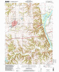
 1990 Meredosia1990 Print · USGSThe Illinois River valley and its surrounding farm towns are captured here in the 1990s. Trace the intricate rail lines of the Norfolk Southern Railway and find local landmarks like Diamond Grove Cem or the Meredosia National Wildlife Refuge.
 - 1998 Map of Griggsville, 2001 Print
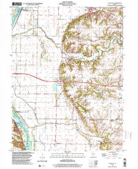
 1998 Griggsville2001 Print · USGSIn the final years of the millennium, this area of Pike County shows the town of Griggsville atop the bluffs overlooking the Illinois River. Researchers can trace old transportation routes like the Old Grade and locate family landmarks such as Elledge Cem and the Holy Family Ch.
 - 1998 Map of Florence, 2003 Print
 1998 Florence2003 Print · USGSIn the late nineties, the Illinois River valley south of Naples remained a landscape of protective levees and scattered upland hamlets. Researchers can trace numerous family burial sites like Exeter Cem and landmarks such as Browns Mound or the Norfolk Southern rail corridor.
End of results
Showing maps 1-3 of 3
Top cities of Scott County
- Winchester historical maps
- Bluffs historical maps
- Manchester historical maps
- Alsey historical maps
- Glasgow historical maps
- Naples historical maps
See more
Frequently asked questions
- What are the different types of historical maps available for Scott County?
- What is the oldest map of Scott County?
- Where can I purchase historical maps of Scott County for my home or office?
- Where can I download high-res historical maps of Scott County?
- Are there historical topographic maps available for Scott County?
- Is there historical aerial imagery available for Scott County?
- Where are historical maps of Scott County sourced from?