1930s Maps of Scott County, Illinois
Explore 2 historic maps of Scott County from the 1930s. These maps offer a rare glimpse into what life looked like during the 1930s — showing old roads, neighborhoods, homes, and landmarks that have changed or disappeared over time.
Whether you're researching your family's past, planning a metal detecting trip, or studying how Scott County's landscape evolved across the 1930s, these high-resolution maps are a powerful tool for exploring the history of this region.
- Focus on a specific era: All maps on this page are from the 1930s, giving you a focused view of this time period.
- See what’s changed: Compare century-old streets, trails, and buildings to today's modern landscape using overlays and satellite layers.
- Research with precision: Use these maps for genealogy, historical research, land use analysis, or educational projects.
- View, download, or print: Maps are fully viewable online in high resolution, and can be downloaded or printed for your own records.
Start exploring Scott County's history through authentic maps from the 1930s. This is your window into the past.
Scott County, IL maps
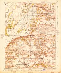
(2)- 1931 Map of Meredosia
 1931 Meredosia1931 Print · USGSThe Illinois River valley in the late twenties is captured here at a peak of rail and river activity. Genealogists can trace family roots through numerous country schools like Sand Ridge Sch and the important La Grange Locks complex.2 unique versions available
 - 1932 Map of Arenzville
 1932 Arenzville1932 Print · USGSThe bluffs and bottomlands of Cass and Morgan Counties are meticulously documented here in the early thirties. Local historians can trace family roots through dozens of rural landmarks, including Jersey College Sch, Bethel Chapel, and the settlement of Joy Prairie.
End of results
Showing maps 1-2 of 2
Top cities of Scott County
- Winchester historical maps
- Bluffs historical maps
- Manchester historical maps
- Alsey historical maps
- Glasgow historical maps
- Naples historical maps
See more
Frequently asked questions
- What are the different types of historical maps available for Scott County?
- What is the oldest map of Scott County?
- Where can I purchase historical maps of Scott County for my home or office?
- Where can I download high-res historical maps of Scott County?
- Are there historical topographic maps available for Scott County?
- Is there historical aerial imagery available for Scott County?
- Where are historical maps of Scott County sourced from?