1970s Maps of Shelby County, Illinois
Explore 1 historic maps of Shelby County from the 1970s. These maps offer a rare glimpse into what life looked like during the 1970s — showing old roads, neighborhoods, homes, and landmarks that have changed or disappeared over time.
Whether you're researching your family's past, planning a metal detecting trip, or studying how Shelby County's landscape evolved across the 1970s, these high-resolution maps are a powerful tool for exploring the history of this region.
- Focus on a specific era: All maps on this page are from the 1970s, giving you a focused view of this time period.
- See what’s changed: Compare century-old streets, trails, and buildings to today's modern landscape using overlays and satellite layers.
- Research with precision: Use these maps for genealogy, historical research, land use analysis, or educational projects.
- View, download, or print: Maps are fully viewable online in high resolution, and can be downloaded or printed for your own records.
Start exploring Shelby County's history through authentic maps from the 1970s. This is your window into the past.
Shelby County, IL maps
(1)- 1974 Map of Ramsey, 1977 Print
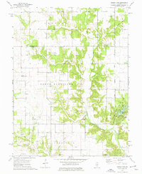 1974 Ramsey1977 Print · USGSMid-century Illinois farmland across Fayette and Montgomery counties is meticulously documented here just as modern conservation took hold. Researchers can trace numerous country burial grounds and rural parishes, including Tennessee Cem, Halford Chapel, and the lakeside Picnic Area of Ramsey Lake State Park.
End of results
Showing maps 1-1 of 1
Top cities of Shelby County
- Shelbyville historical maps
- Windsor historical maps
- Stewardson historical maps
- Findlay historical maps
- Tower Hill historical maps
- Cowden historical maps
See more
Frequently asked questions
- What are the different types of historical maps available for Shelby County?
- What is the oldest map of Shelby County?
- Where can I purchase historical maps of Shelby County for my home or office?
- Where can I download high-res historical maps of Shelby County?
- Are there historical topographic maps available for Shelby County?
- Is there historical aerial imagery available for Shelby County?
- Where are historical maps of Shelby County sourced from?