1980s Maps of Middlesworth, Illinois
Explore 3 historic maps of Middlesworth from the 1980s. These maps offer a rare glimpse into what life looked like during the 1980s — showing old roads, neighborhoods, homes, and landmarks that have changed or disappeared over time.
Whether you're researching your family's past, planning a metal detecting trip, or studying how Middlesworth's landscape evolved across the 1980s, these high-resolution maps are a powerful tool for exploring the history of this region.
- Focus on a specific era: All maps on this page are from the 1980s, giving you a focused view of this time period.
- See what’s changed: Compare century-old streets, trails, and buildings to today's modern landscape using overlays and satellite layers.
- Research with precision: Use these maps for genealogy, historical research, land use analysis, or educational projects.
- View, download, or print: Maps are fully viewable online in high resolution, and can be downloaded or printed for your own records.
Start exploring Middlesworth's history through authentic maps from the 1980s. This is your window into the past.
Middlesworth, IL maps
(3)- 1980 Map of Middlesworth
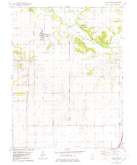 1980 Middlesworth1980 Print · USGSThe rural landscapes at the Menard and Logan County line are captured here in the late twentieth century. Researchers can trace family history at Irish Grove Cemetery and Walnut Ridge Cemetery or follow the route of the Old Grade Railroad.
 - 1981 Map of Middlesworth, 1982 Print
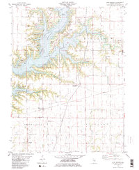 1981 Middlesworth1982 Print · USGSShelby County enters the 1980s with the massive Lake Shelbyville reservoir reshaping the rural landscape. Genealogists and historians can locate over a dozen burial sites including Caldwell Cem and Oak Grove Cem, alongside the CONRAIL tracks.2 unique versions available
 - 1986 Map of Effingham
 1986 Effingham1986 Print · USGSCentral Illinois during the mid-eighties was a hub of rail travel and water recreation centered on the new reservoirs. Genealogists and historians can trace the rural landscape between Mattoon and Effingham, locating landmarks like St Paul Ch and Eagle Creek State Park.2 unique versions available
End of results
Showing maps 1-3 of 3
Top cities near Middlesworth
- Shelbyville historical maps
- Sullivan historical maps
- Bethany historical maps
- Windsor historical maps
- Stewardson historical maps
- Findlay historical maps
See more
Frequently asked questions
- What are the different types of historical maps available for Middlesworth?
- What is the oldest map of Middlesworth?
- Where can I purchase historical maps of Middlesworth for my home or office?
- Where can I download high-res historical maps of Middlesworth?
- Are there historical topographic maps available for Middlesworth?
- Is there historical aerial imagery available for Middlesworth?
- Where are historical maps of Middlesworth sourced from?