1960s Maps of Wabash County, Illinois
Explore 3 historic maps of Wabash County from the 1960s. These maps offer a rare glimpse into what life looked like during the 1960s — showing old roads, neighborhoods, homes, and landmarks that have changed or disappeared over time.
Whether you're researching your family's past, planning a metal detecting trip, or studying how Wabash County's landscape evolved across the 1960s, these high-resolution maps are a powerful tool for exploring the history of this region.
- Focus on a specific era: All maps on this page are from the 1960s, giving you a focused view of this time period.
- See what’s changed: Compare century-old streets, trails, and buildings to today's modern landscape using overlays and satellite layers.
- Research with precision: Use these maps for genealogy, historical research, land use analysis, or educational projects.
- View, download, or print: Maps are fully viewable online in high resolution, and can be downloaded or printed for your own records.
Start exploring Wabash County's history through authentic maps from the 1960s. This is your window into the past.
Wabash County, IL maps
(3)- 1964 Map of St. Francisville, 1966 Print
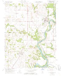 1964 St. Francisville1966 Print · USGSThe Wabash River valley in the mid-sixties reveals a landscape shaped by river bends and rail lines. Genealogists can trace rural roots through numerous sites like Jordan Cem, New Bethel Ch, and the streets of St Francisville.3 unique versions available
 - 1968 Map of Berryville, 1969 Print
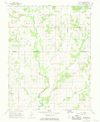 1968 Berryville1969 Print · USGSSoutheast Illinois at the end of the sixties reveals a rural landscape where county lines meet along the Old Indian Treaty Boundary. Genealogists can locate several family landmarks and burial sites like Welser Cem, Pinhook Cem, and Pleasant Grove Ch.
 - 1968 Map of Lancaster, 1970 Print
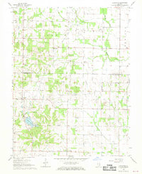 1968 Lancaster1970 Print · USGSWabash and Lawrence Counties are shown here in the late sixties as an active landscape of prairie farming and oil production. Researchers can trace rural lineages through family landmarks like Moffett Cem or visit small hubs like Lancaster and Orio.
End of results
Showing maps 1-3 of 3
Top cities of Wabash County
- Mount Carmel historical maps
- Allendale historical maps
- Bellmont historical maps
- Keensburg historical maps
Frequently asked questions
- What are the different types of historical maps available for Wabash County?
- What is the oldest map of Wabash County?
- Where can I purchase historical maps of Wabash County for my home or office?
- Where can I download high-res historical maps of Wabash County?
- Are there historical topographic maps available for Wabash County?
- Is there historical aerial imagery available for Wabash County?
- Where are historical maps of Wabash County sourced from?