1980s Maps of Kirkwood, Illinois
Explore 5 historic maps of Kirkwood from the 1980s. These maps offer a rare glimpse into what life looked like during the 1980s — showing old roads, neighborhoods, homes, and landmarks that have changed or disappeared over time.
Whether you're researching your family's past, planning a metal detecting trip, or studying how Kirkwood's landscape evolved across the 1980s, these high-resolution maps are a powerful tool for exploring the history of this region.
- Focus on a specific era: All maps on this page are from the 1980s, giving you a focused view of this time period.
- See what’s changed: Compare century-old streets, trails, and buildings to today's modern landscape using overlays and satellite layers.
- Research with precision: Use these maps for genealogy, historical research, land use analysis, or educational projects.
- View, download, or print: Maps are fully viewable online in high resolution, and can be downloaded or printed for your own records.
Start exploring Kirkwood's history through authentic maps from the 1980s. This is your window into the past.
Kirkwood, IL maps
(5)- 1982 Map of Kirkwood West, 1983 Print
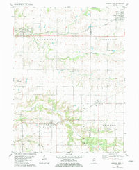 1982 Kirkwood West1983 Print · USGSHenderson and Warren Counties are seen here in the early eighties as the railroads supported a network of grain-handling prairie towns. Genealogists can locate family sites at Salters Grove Cem, Adair Cem, and Township Cem near the village of Media.
 - 1982 Map of Kirkwood East, 1983 Print
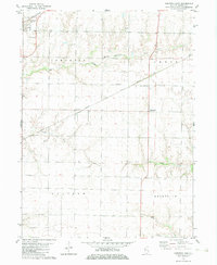 1982 Kirkwood East1983 Print · USGSWarren County farmland shows its late-century agricultural and rail character in the early eighties. Genealogists can locate Hickory Point Cem and County Farm Cem or trace the routes of the Burlington Northern through Kirkwood.
 - 1982 Map of Monmouth, 1983 Print
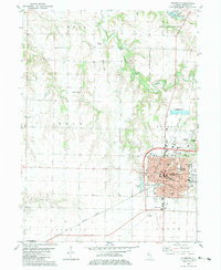 1982 Monmouth1983 Print · USGSMonmouth and its surrounding townships are shown in the early eighties as the town grew around Monmouth College. Genealogists can trace family roots at St Marys Cem or Sugar Tree Grove Cem, while the Burlington Northern line defines the local rail economy.
 - 1985 Map of Galesburg, 1986 Print
 1985 Galesburg1986 Print · USGSWestern Illinois in the mid-eighties was a landscape of riverfront forests and industrial rail hubs. Genealogists and historians can trace the growth of Galesburg and Monmouth alongside rural landmarks like Stronghurst and the coal operations of the Strip Mine near Canton.2 unique versions available
 - 1989 Map of Galesburg
 1989 Galesburg1989 Print · USGSWestern Illinois in the late eighties reveals a landscape of industrial rail hubs and riverfront timberland. Genealogists and historians can trace the routes of the Atchison Topeka and Santa Fe RR through small towns like Stronghurst, London Mills, and Middle Grove (Middlepoint).
End of results
Showing maps 1-5 of 5
Top cities near Kirkwood
- Monmouth historical maps
- Oquawka historical maps
- Roseville historical maps
- Stronghurst historical maps
- Keithsburg historical maps
- Greenbush historical maps
See more
Frequently asked questions
- What are the different types of historical maps available for Kirkwood?
- What is the oldest map of Kirkwood?
- Where can I purchase historical maps of Kirkwood for my home or office?
- Where can I download high-res historical maps of Kirkwood?
- Are there historical topographic maps available for Kirkwood?
- Is there historical aerial imagery available for Kirkwood?
- Where are historical maps of Kirkwood sourced from?