1970s Maps of Keenesville, Illinois
Explore 1 historic maps of Keenesville from the 1970s. These maps offer a rare glimpse into what life looked like during the 1970s — showing old roads, neighborhoods, homes, and landmarks that have changed or disappeared over time.
Whether you're researching your family's past, planning a metal detecting trip, or studying how Keenesville's landscape evolved across the 1970s, these high-resolution maps are a powerful tool for exploring the history of this region.
- Focus on a specific era: All maps on this page are from the 1970s, giving you a focused view of this time period.
- See what’s changed: Compare century-old streets, trails, and buildings to today's modern landscape using overlays and satellite layers.
- Research with precision: Use these maps for genealogy, historical research, land use analysis, or educational projects.
- View, download, or print: Maps are fully viewable online in high resolution, and can be downloaded or printed for your own records.
Start exploring Keenesville's history through authentic maps from the 1970s. This is your window into the past.
Keenesville, IL maps
(1)- 1973 Map of Shields, 1975 Print
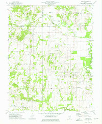 1973 Shields1975 Print · USGSWayne and Jefferson counties come alive in the early seventies, showing a landscape defined by the Orchardville Oil Field and rural river crossings. Trace family roots at the McConaughhay Cem, locate the old Ten Foot Oak Ch, or follow the Skillet Fork to Greathouse Ford.
End of results
Showing maps 1-1 of 1
Top cities near Keenesville
- Mount Vernon historical maps
- Fairfield historical maps
- Wayne City historical maps
- Bluford historical maps
- Cisne historical maps
- Iuka historical maps
See more
Frequently asked questions
- What are the different types of historical maps available for Keenesville?
- What is the oldest map of Keenesville?
- Where can I purchase historical maps of Keenesville for my home or office?
- Where can I download high-res historical maps of Keenesville?
- Are there historical topographic maps available for Keenesville?
- Is there historical aerial imagery available for Keenesville?
- Where are historical maps of Keenesville sourced from?