1940s Maps of Mill Shoals, Illinois
Explore 3 historic maps of Mill Shoals from the 1940s. These maps offer a rare glimpse into what life looked like during the 1940s — showing old roads, neighborhoods, homes, and landmarks that have changed or disappeared over time.
Whether you're researching your family's past, planning a metal detecting trip, or studying how Mill Shoals's landscape evolved across the 1940s, these high-resolution maps are a powerful tool for exploring the history of this region.
- Focus on a specific era: All maps on this page are from the 1940s, giving you a focused view of this time period.
- See what’s changed: Compare century-old streets, trails, and buildings to today's modern landscape using overlays and satellite layers.
- Research with precision: Use these maps for genealogy, historical research, land use analysis, or educational projects.
- View, download, or print: Maps are fully viewable online in high resolution, and can be downloaded or printed for your own records.
Start exploring Mill Shoals's history through authentic maps from the 1940s. This is your window into the past.
Mill Shoals, IL maps
(3)- 1941 Map of Enfield, 1968 Print
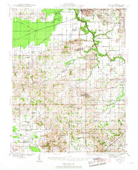 1941 Enfield1968 Print · USGSWhite and Hamilton counties in the early 1940s were defined by a vast network of rural school districts and rail-connected hamlets. Genealogists can trace family roots through numerous local landmarks, from the Burnt Prairie P O to the McIntosh Cem and Wildcat Sch.
 - 1944 Map of Enfield
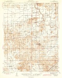 1944 Enfield1944 Print · USGSSoutheastern Illinois in the early 1940s is defined here by a dense grid of rural schools and the intersection of major rail lines. Researchers can trace ancestral locations through the dozens of named institutions like McIntosh Settlement, Asbury Ch, and Trousdale Sch.2 unique versions available
 - 1948 Map of Fairfield
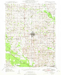 1948 Fairfield1948 Print · USGSWayne County is captured in the late 1940s as a thriving network of small rail towns and rural school districts. Genealogists and historians can trace family locations near Pure Gold Sch, the Crews Cem, or the rail junction at Fairfield.2 unique versions available
End of results
Showing maps 1-3 of 3
Top cities near Mill Shoals
- Fairfield historical maps
- Carmi historical maps
- McLeansboro historical maps
- Enfield historical maps
- Barnhill historical maps
- Sims historical maps
See more
Frequently asked questions
- What are the different types of historical maps available for Mill Shoals?
- What is the oldest map of Mill Shoals?
- Where can I purchase historical maps of Mill Shoals for my home or office?
- Where can I download high-res historical maps of Mill Shoals?
- Are there historical topographic maps available for Mill Shoals?
- Is there historical aerial imagery available for Mill Shoals?
- Where are historical maps of Mill Shoals sourced from?