1940s Maps of Rockford, Rockford Township
Explore 3 historic maps of Rockford from the 1940s. These maps offer a rare glimpse into what life looked like during the 1940s — showing old roads, neighborhoods, homes, and landmarks that have changed or disappeared over time.
Whether you're researching your family's past, planning a metal detecting trip, or studying how Rockford's landscape evolved across the 1940s, these high-resolution maps are a powerful tool for exploring the history of this region.
- Focus on a specific era: All maps on this page are from the 1940s, giving you a focused view of this time period.
- See what’s changed: Compare century-old streets, trails, and buildings to today's modern landscape using overlays and satellite layers.
- Research with precision: Use these maps for genealogy, historical research, land use analysis, or educational projects.
- View, download, or print: Maps are fully viewable online in high resolution, and can be downloaded or printed for your own records.
Start exploring Rockford's history through authentic maps from the 1940s. This is your window into the past.
Rockford, Rockford Township maps
(3)- 1944 Map of Belvidere
 1944 Belvidere1944 Print · USGSNorthern Illinois at the height of the Second World War shows a landscape defined by rail-fed farming villages and dozens of country schoolhouses. Genealogists can trace family footprints near Scotch Church, the Fairgrounds, and settlements like Poplar Grove.2 unique versions available
 - 1949 Map of Camp Grant
 1949 Camp Grant1949 Print · USGSThe industrial and military landscape south of Rockford is captured here shortly after the war, when Camp Grant still shaped the riverfront. Trace the routes of three major railroads and find vanished local landmarks like New Milford Sta and Blackhawk Sch.
 - 1949 Map of Rockford
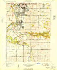
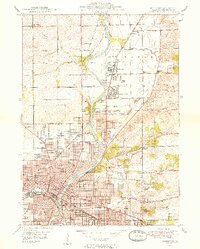 1949 Rockford1949 Print · USGSMid-century Rockford and the Rock River valley appear here in a period of rapid post-war growth and industrial strength. Researchers can trace historic family locations through numerous sites like Harlem Ch, Machesney Landing Field, and West High Sch.2 unique versions available
End of results
Showing maps 1-3 of 3
Top cities near Rockford
- Belvidere historical maps
- Loves Park historical maps
- Machesney Park historical maps
- Roscoe historical maps
- South Beloit historical maps
- Rockton historical maps
See more
Top neighborhoods of Rockford
- Winnebago Court historical maps
- Morris Kennedy Subdivision historical maps
- Normandy Heights historical maps
- Ravinia Park historical maps
- Silver Hills historical maps
- Kishwaukee Subdivision historical maps
See more
Frequently asked questions
- What are the different types of historical maps available for Rockford?
- What is the oldest map of Rockford?
- Where can I purchase historical maps of Rockford for my home or office?
- Where can I download high-res historical maps of Rockford?
- Are there historical topographic maps available for Rockford?
- Is there historical aerial imagery available for Rockford?
- Where are historical maps of Rockford sourced from?