1970s Maps of Rockford, Rockford Township
Explore 5 historic maps of Rockford from the 1970s. These maps offer a rare glimpse into what life looked like during the 1970s — showing old roads, neighborhoods, homes, and landmarks that have changed or disappeared over time.
Whether you're researching your family's past, planning a metal detecting trip, or studying how Rockford's landscape evolved across the 1970s, these high-resolution maps are a powerful tool for exploring the history of this region.
- Focus on a specific era: All maps on this page are from the 1970s, giving you a focused view of this time period.
- See what’s changed: Compare century-old streets, trails, and buildings to today's modern landscape using overlays and satellite layers.
- Research with precision: Use these maps for genealogy, historical research, land use analysis, or educational projects.
- View, download, or print: Maps are fully viewable online in high resolution, and can be downloaded or printed for your own records.
Start exploring Rockford's history through authentic maps from the 1970s. This is your window into the past.
Rockford, Rockford Township maps
(5)- 1970 Map of Caledonia, 1972 Print
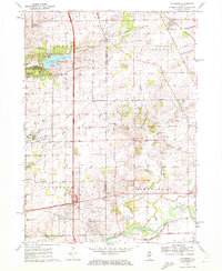 1970 Caledonia1972 Print · USGSCaledonia and the northern outskirts of Rockford are captured in the early 1970s as suburban growth met rural prairie. Genealogists can locate Guilford Union Cem, Orth Cem, and Bell Sch among the family-named roads and gravel works.2 unique versions available
 - 1971 Map of Rockford North, 1973 Print
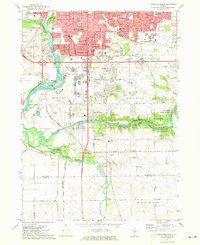
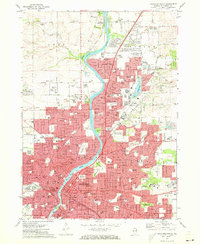 1971 Rockford North1973 Print · USGSThe Rock River Valley in the early 1970s shows a region transitioning from its industrial roots to modern suburban growth. Genealogists and historians can trace family locations through sites like Cedar Bluff Cemetery, Rockford College, and the Scandinavian Cem.2 unique versions available
 - 1971 Map of Kishwaukee, 1973 Print
 1971 Kishwaukee1973 Print · USGSWinnebago and Ogle Counties are captured here in the early seventies as the river valleys supported both industry and recreation. Genealogists and local historians can locate Winnebago Cemetery, rural schools like Oak Grove, and the Alworth settlement.
 - 1971 Map of Winnebago, 1973 Print
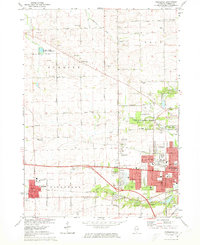 1971 Winnebago1973 Print · USGSWestern Winnebago County appears in the early seventies as the city of Rockford begins to meet the quiet farmland of Burritt Township. Researchers can trace the heritage of local families through North Burritt Cem, identify early school sites like McNair Sch, and locate the historic Chicago and North Western rail line.2 unique versions available
 - 1971 Map of Rockford South, 1973 Print
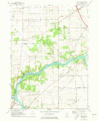
 1971 Rockford South1973 Print · USGSSouthern Rockford and the surrounding Winnebago County countryside appear here in the early seventies as suburban growth began to reach toward the Ogle County line. Researchers can trace local landmarks like Starkey Cem, the Grange Hall, and small communities such as New Milford and Morristown.2 unique versions available
End of results
Showing maps 1-5 of 5
Top cities near Rockford
- Belvidere historical maps
- Loves Park historical maps
- Machesney Park historical maps
- Roscoe historical maps
- South Beloit historical maps
- Rockton historical maps
See more
Top neighborhoods of Rockford
- Winnebago Court historical maps
- Morris Kennedy Subdivision historical maps
- Normandy Heights historical maps
- Ravinia Park historical maps
- Silver Hills historical maps
- Kishwaukee Subdivision historical maps
See more
Frequently asked questions
- What are the different types of historical maps available for Rockford?
- What is the oldest map of Rockford?
- Where can I purchase historical maps of Rockford for my home or office?
- Where can I download high-res historical maps of Rockford?
- Are there historical topographic maps available for Rockford?
- Is there historical aerial imagery available for Rockford?
- Where are historical maps of Rockford sourced from?