1960s Maps of Thorntown, Indiana
Explore 2 historic maps of Thorntown from the 1960s. These maps offer a rare glimpse into what life looked like during the 1960s — showing old roads, neighborhoods, homes, and landmarks that have changed or disappeared over time.
Whether you're researching your family's past, planning a metal detecting trip, or studying how Thorntown's landscape evolved across the 1960s, these high-resolution maps are a powerful tool for exploring the history of this region.
- Focus on a specific era: All maps on this page are from the 1960s, giving you a focused view of this time period.
- See what’s changed: Compare century-old streets, trails, and buildings to today's modern landscape using overlays and satellite layers.
- Research with precision: Use these maps for genealogy, historical research, land use analysis, or educational projects.
- View, download, or print: Maps are fully viewable online in high resolution, and can be downloaded or printed for your own records.
Start exploring Thorntown's history through authentic maps from the 1960s. This is your window into the past.
Thorntown, IN maps
(2)- 1961 Map of Hazelrigg, 1963 Print
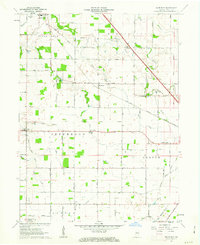 1961 Hazelrigg1963 Print · USGSBoone County's agricultural and rail-oriented landscape is captured here in the early sixties, showing the vital connection between small towns and the New York Central Railroad. Genealogists and historians can locate family sites near Thorntown, Hazelrigg, and Dover, or trace landmarks like the Township Sch and Pleasant View Cem.2 unique versions available
 - 1962 Map of Thorntown, 1963 Print
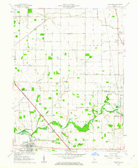 1962 Thorntown1963 Print · USGSThorntown and the surrounding Boone County farmland are captured in the early sixties as a network of rail-side settlements and rural parishes. Genealogists and local historians can trace family-named landmarks like Maple Lawn Cem, Kinder Ch, and the Old Indian Treaty Boundary.3 unique versions available
End of results
Showing maps 1-2 of 2
Top cities near Thorntown
- Lafayette historical maps
- Frankfort historical maps
- Lebanon historical maps
- Mulberry historical maps
- Ladoga historical maps
- Jamestown historical maps
See more
Frequently asked questions
- What are the different types of historical maps available for Thorntown?
- What is the oldest map of Thorntown?
- Where can I purchase historical maps of Thorntown for my home or office?
- Where can I download high-res historical maps of Thorntown?
- Are there historical topographic maps available for Thorntown?
- Is there historical aerial imagery available for Thorntown?
- Where are historical maps of Thorntown sourced from?