1960s Maps of Mount Liberty, Indiana
Explore 2 historic maps of Mount Liberty from the 1960s. These maps offer a rare glimpse into what life looked like during the 1960s — showing old roads, neighborhoods, homes, and landmarks that have changed or disappeared over time.
Whether you're researching your family's past, planning a metal detecting trip, or studying how Mount Liberty's landscape evolved across the 1960s, these high-resolution maps are a powerful tool for exploring the history of this region.
- Focus on a specific era: All maps on this page are from the 1960s, giving you a focused view of this time period.
- See what’s changed: Compare century-old streets, trails, and buildings to today's modern landscape using overlays and satellite layers.
- Research with precision: Use these maps for genealogy, historical research, land use analysis, or educational projects.
- View, download, or print: Maps are fully viewable online in high resolution, and can be downloaded or printed for your own records.
Start exploring Mount Liberty's history through authentic maps from the 1960s. This is your window into the past.
Mount Liberty, IN maps
(2)- 1961 Map of Nashville, 1963 Print
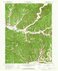 1961 Nashville1963 Print · USGSThe hills of Brown County are captured here in the early sixties, showing the integration of forest preserves and small rural crossroads. Researchers can locate family landmarks like Reeves Cem, historic St Agnes Ch, and the curious settlement of Gnaw Bone.5 unique versions available
 - 1962 Map of Indianapolis
 1962 Indianapolis1962 Print · USGSCentral Indiana and the Illinois borderlands are captured here in the early sixties, showing the region's dense rail networks and growing urban centers. Genealogists and historians can locate family-named landmarks and institutions like Crown Hill Cem, Indiana University, and the Indianapolis Motor Speedway.
End of results
Showing maps 1-2 of 2
Top cities near Mount Liberty
- Columbus historical maps
- Seymour historical maps
- Nineveh historical maps
- Princes Lakes historical maps
- Trafalgar historical maps
- Morgantown historical maps
See more
Frequently asked questions
- What are the different types of historical maps available for Mount Liberty?
- What is the oldest map of Mount Liberty?
- Where can I purchase historical maps of Mount Liberty for my home or office?
- Where can I download high-res historical maps of Mount Liberty?
- Are there historical topographic maps available for Mount Liberty?
- Is there historical aerial imagery available for Mount Liberty?
- Where are historical maps of Mount Liberty sourced from?