1940s Maps of Spearsville, Indiana
Explore 3 historic maps of Spearsville from the 1940s. These maps offer a rare glimpse into what life looked like during the 1940s — showing old roads, neighborhoods, homes, and landmarks that have changed or disappeared over time.
Whether you're researching your family's past, planning a metal detecting trip, or studying how Spearsville's landscape evolved across the 1940s, these high-resolution maps are a powerful tool for exploring the history of this region.
- Focus on a specific era: All maps on this page are from the 1940s, giving you a focused view of this time period.
- See what’s changed: Compare century-old streets, trails, and buildings to today's modern landscape using overlays and satellite layers.
- Research with precision: Use these maps for genealogy, historical research, land use analysis, or educational projects.
- View, download, or print: Maps are fully viewable online in high resolution, and can be downloaded or printed for your own records.
Start exploring Spearsville's history through authentic maps from the 1940s. This is your window into the past.
Spearsville, IN maps
(3)- 1942 Map of Franklin
 1942 Franklin1942 Print · USGSCentral Indiana during the early years of the war shows a landscape of established rail towns and growing military installations. Genealogists can trace family names across small settlements like Nineveh, Bean Blossom, and Helmsburg, or locate the Indiana University Observatory.
 - 1947 Map of Franklin, 1964 Print
 1947 Franklin1964 Print · USGSMid-century Johnson County is captured here during a period of significant military activity and established civic life. Genealogists and local historians can locate Franklin College, the Prisoner of War Camp at Camp Atterbury, and numerous rural sites like Lick Spring Church and Hopewell Cem.
 - 1948 Map of Fruitdale
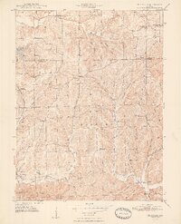 1948 Fruitdale1948 Print · USGSNear the border of Johnson and Brown counties in the late 1940s, this area shows a landscape of ridge-top roads and tucked-away hollows. Genealogists can trace family names through landmarks like Duncan Cem, Spearsville Sch, and the Illinois Central rail line.3 unique versions available
End of results
Showing maps 1-3 of 3
Top cities near Spearsville
- Greenwood historical maps
- Columbus historical maps
- Franklin historical maps
- Martinsville historical maps
- New Whiteland historical maps
- Nineveh historical maps
See more
Frequently asked questions
- What are the different types of historical maps available for Spearsville?
- What is the oldest map of Spearsville?
- Where can I purchase historical maps of Spearsville for my home or office?
- Where can I download high-res historical maps of Spearsville?
- Are there historical topographic maps available for Spearsville?
- Is there historical aerial imagery available for Spearsville?
- Where are historical maps of Spearsville sourced from?