1990s Maps of Jeffersonville, Indiana
Explore 2 historic maps of Jeffersonville from the 1990s. These maps offer a rare glimpse into what life looked like during the 1990s — showing old roads, neighborhoods, homes, and landmarks that have changed or disappeared over time.
Whether you're researching your family's past, planning a metal detecting trip, or studying how Jeffersonville's landscape evolved across the 1990s, these high-resolution maps are a powerful tool for exploring the history of this region.
- Focus on a specific era: All maps on this page are from the 1990s, giving you a focused view of this time period.
- See what’s changed: Compare century-old streets, trails, and buildings to today's modern landscape using overlays and satellite layers.
- Research with precision: Use these maps for genealogy, historical research, land use analysis, or educational projects.
- View, download, or print: Maps are fully viewable online in high resolution, and can be downloaded or printed for your own records.
Start exploring Jeffersonville's history through authentic maps from the 1990s. This is your window into the past.
Jeffersonville, IN maps
(2)- 1992 Map of New Albany, 1995 Print
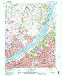
 1992 New Albany1995 Print · USGSThe Ohio River corridor comes alive in the early 1990s as it connects New Albany and Clarksville with Louisville. Researchers can trace historic river navigation through McAlpine Locks or locate family sites at Fairview Cem and Blackiston Mill.2 unique versions available
 - 1993 Map of Jeffersonville, 1995 Print
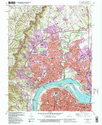
 1993 Jeffersonville1995 Print · USGSThe riverfront between Indiana and Kentucky thrived in the early nineties as industry and suburbs expanded alongside historic cemeteries. Trace family roots and local growth through landmarks like the Zachary Taylor National Cem, the Big Four Bridge, and the Kentucky Railway Museum.2 unique versions available
End of results
Showing maps 1-2 of 2
Top cities near Jeffersonville
- Louisville historical maps
- New Albany historical maps
- Jeffersontown historical maps
- Clarksville historical maps
- Shively historical maps
- Lyndon historical maps
See more
Top neighborhoods of Jeffersonville
- Port Fulton historical maps
- Arctic Springs historical maps
- Cementville historical maps
- Loma Vista historical maps
- Mallard Run historical maps
- Northhaven historical maps
See more
Frequently asked questions
- What are the different types of historical maps available for Jeffersonville?
- What is the oldest map of Jeffersonville?
- Where can I purchase historical maps of Jeffersonville for my home or office?
- Where can I download high-res historical maps of Jeffersonville?
- Are there historical topographic maps available for Jeffersonville?
- Is there historical aerial imagery available for Jeffersonville?
- Where are historical maps of Jeffersonville sourced from?